Hrabstwo Lincoln (Nevada)
| ||||
| ||||
 | ||||
| Państwo | ||||
|---|---|---|---|---|
| Stan | ||||
| Siedziba | Pioche | |||
| Kod statystyczny | FIPS 6-4: 32017 | |||
| Powierzchnia | 27 549 km² | |||
| Populacja (2000) • liczba ludności | 4165 | |||
| • gęstość | 0,15 os./km² | |||
Położenie na mapie Nevada | ||||
| Strona internetowa | ||||
| Portal | ||||
Hrabstwo Lincoln (ang. Lincoln County) – amerykańskie hrabstwo w południowo-wschodniej części stanu Nevada. Populacja w roku 2000 wyniosła 4 165. Stolicą jest Pioche.
Historia
Hrabstwo Lincoln powstało w roku 1861. Jest jednym z dziewięciu oryginalnych hrabstw Terytorium Nevady. Pierwotnie miało się nazywać Stewart na cześć senatora Williama Stewarta. Ostatecznie w roku 1866 przyjęto nazwisko szesnastego prezydenta Stanów Zjednoczonych, który przyłączył Nevadę do Unii. Stolicą prowizorycznego hrabstwa zostało w roku 1861 Crystal Springs. W latach 1867-1871 siedzibą władz było Hiko. Od roku 1871 w Pioche. W 1957 roku w południowo-zachodniej części została założona Strefa 51. Wielu mieszkańców utrzymuje się z obsługi turystów.
Geografia
Całkowity obszar 27 549 km². Rozległa pustynia. Woda stanowi zaledwie 0,03% powierzchni. Południowo-zachodnia część, w granicach Strefy Sił Powietrznych Nellis.
Miasta
- Alamo
- Caliente
CDP
- Alamo
- Beaverdam
- Bennett Springs
- Dry Valley
- Hiko
- Mount Wilson
- Panaca
- Pioche
- Rachel
- Ursine
Sąsiednie hrabstwa
- Clark – południe
- Nye – zachód
- White Pine – północ
- Mohave w Arizonie – południowy zachód
- Washington w Utah – wschód
- Iron w Utah – wschód
- Beaver w Utah – wschód
- Millard w Utah – północny wschód
Edukacja
Znajdują się tu następujące uczelnie (wszystkie w trakcie budowy):
- Pioche Elementary School
- Caliente Elementary School
- Pahranagat Valley Elementary School
- Panaca Elementary School
- Meadow Valley Middle School
- Pahranagat Valley Middle School
- Lincoln County High School
- C. O. Bastian High School
- Pahranagat Valley High School
Media użyte na tej stronie
The flag of Navassa Island is simply the United States flag. It does not have a "local" flag or "unofficial" flag; it is an uninhabited island. The version with a profile view was based on Flags of the World and as a fictional design has no status warranting a place on any Wiki. It was made up by a random person with no connection to the island, it has never flown on the island, and it has never received any sort of recognition or validation by any authority. The person quoted on that page has no authority to bestow a flag, "unofficial" or otherwise, on the island.
Flag of the State of Nevada. The flag is described in Nevada Revised Statutes Chapter 235, Sec. 20 as follows: The body of the flag must be of solid cobalt blue. On the field in the upper left quarter thereof must be two sprays of Sagebrush with the stems crossed at the bottom to form a half wreath. Within the sprays must be a five-pointed silver star with one point up. The word “Nevada” must also be inscribed below the star and above the sprays, in a semicircular pattern with the letters spaced apart in equal increments, in the same style of letters as the words “Battle Born.” Above the wreath, and touching the tips thereof, must be a scroll bearing the words “Battle Born.” The scroll and the word “Nevada” must be golden-yellow. The lettering on the scroll must be black-colored sans serif gothic capital letters.
Autor:
- real name: Artur Jan Fijałkowski
- pl.wiki: WarX
- commons: WarX
- mail: [1]
- jabber: WarX@jabber.org
- irc: [2]
- software: own perl scripts
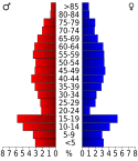
Piramida wieku dla hrabstwa Lincoln w stanie Nevada w USA na podstawie spisu ludności z 2000 roku
Autor: Vicki Streeter and James Ferrigan III, Licencja: CC BY-SA 4.0
Flag of Lincoln County, Nevada
Autor: Finetooth, Licencja: CC BY-SA 3.0
Courthouse in Lincoln County, Nevada, in the United States. Pioche is the county seat.
This is a locator map showing Lincoln County in Nevada. For more information, see Commons:United States county locator maps.


