Hrabstwo Madison (Nowy Jork)
| ||||
| ||||
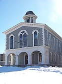
 Historyczny budynek władz hrabstwa w Wampsville | ||||
| Państwo | ||||
|---|---|---|---|---|
| Stan | ||||
| Siedziba | Wampsville | |||
| Powierzchnia | 1713 km²[1] | |||
| Populacja (2010) • liczba ludności | 73 442[2] | |||
| • gęstość | 41 os./km² | |||
| Strefa czasowa | UTC-05:00 UTC-04:00 | |||
Położenie na mapie stanu Nowy Jork (c) NordNordWest, CC BY 3.0 | ||||
| Strona internetowa | ||||
| Portal | ||||
Madison – hrabstwo w stanie Nowy Jork w USA. Znajduje się na czwartym miejscu w rankingu na najlepsze miejsce do życia w północno-wschodniej części USA.
W 2000 r. liczba mieszkańców wynosiła 69 441 osób. Hrabstwo zostało nazwane na cześć czwartego prezydenta USA Jamesa Madisona. Siedzibą urzędu jest Wampsville.
Hrabstwo Madison jest częścią Metropolii Syracuse.
Co roku w czerwcu w Syracuse Polski Stypendialny Fundusz organizuje na Clinton Square największy w płn.-wsch. części USA "Polski Festiwal", ze średnią frekwencją ponad 25 000.
Miejscowości
Wsie
- Bridgeport (CDP)
- Canastota
- Cazenovia
- Chittenango
- DeRuyter
- Hamilton
- Madison
- Morrisville
- Munnsville
- Wampsville
Przypisy
- ↑ QuickFacts, Madison County, New York (ang.). U.S. Census Bureau. [dostęp 2018-07-25].
- ↑ Madison County, New York Population Census 2010 and 2000 Interactive Map, Demographics, Statistics, Graph (ang.). CensusViewer. [dostęp 2018-07-26].
Media użyte na tej stronie
(c) NordNordWest, CC BY 3.0
Location map of the State of New York, USA
Autor: Uwe Dedering, Licencja: CC BY-SA 3.0
Location map of the USA (without Hawaii and Alaska).
EquiDistantConicProjection:
Central parallel:
* N: 37.0° N
Central meridian:
* E: 96.0° W
Standard parallels:
* 1: 32.0° N
* 2: 42.0° N
Made with Natural Earth. Free vector and raster map data @ naturalearthdata.com.
Formulas for x and y:
x = 50.0 + 124.03149777329222 * ((1.9694462586094064-({{{2}}}* pi / 180))
      * sin(0.6010514667026994 * ({{{3}}} + 96) * pi / 180))
y = 50.0 + 1.6155950752393982 * 124.03149777329222 * 0.02613325650382181
      - 1.6155950752393982  * 124.03149777329222 *
     (1.3236744353715044  - (1.9694462586094064-({{{2}}}* pi / 180))
      * cos(0.6010514667026994 * ({{{3}}} + 96) * pi / 180))
The flag of Navassa Island is simply the United States flag. It does not have a "local" flag or "unofficial" flag; it is an uninhabited island. The version with a profile view was based on Flags of the World and as a fictional design has no status warranting a place on any Wiki. It was made up by a random person with no connection to the island, it has never flown on the island, and it has never received any sort of recognition or validation by any authority. The person quoted on that page has no authority to bestow a flag, "unofficial" or otherwise, on the island.


