Hrabstwo Mahoning
| hrabstwo | |||
 Sąd hrabstwa Mahoning. | |||
| |||
| Państwo | |||
|---|---|---|---|
| Stan | |||
| Kod statystyczny | FIPS 6-4: 39099 | ||
| Powierzchnia | 1097 km² | ||
| Populacja (2020) • liczba ludności | 228 614 | ||
| • gęstość | 210 os./km² | ||
Położenie na mapie Ohio | |||
| Portal | |||
Hrabstwo Mahoning – hrabstwo w USA, w stanie Ohio. Według spisu z 2020 roku liczba ludności spadła o 4,3% (od 2010) do 228,6 tys. mieszkańców[1].
Geografia
Sąsiednie hrabstwa
- hrabstwo Trumbull (północ)
- hrabstwo Mercer (północny wschód)
- hrabstwo Lawrence (wschód)
- hrabstwo Columbiana (południe)
- hrabstwo Stark (południowy zachód)
- hrabstwo Portage (południowy wschód)
Miasta
Wioski
CDP
Demografia
Według danych za lata 2014–2019 w hrabstwie 79,7% mieszkańców stanowiła ludność biała (76,0% nie licząc Latynosów), 15,1% to byli czarnoskórzy Amerykanie lub Afroamerykanie, 3,2% miało rasę mieszaną, 0,9% to byli Azjaci, 0,3% to rdzenna ludność Ameryki i 0,04% pochodziło z wysp Pacyfiku. Latynosi stanowili 6,0% ludności hrabstwa[2].
Do największych grup należały osoby pochodzenia niemieckiego (18,9%), włoskiego (18,5%), irlandzkiego (15,1%), afroamerykańskiego, „amerykańskiego” (7,3%), angielskiego (7,2%), słowackiego (6,2%), polskiego (4,6%) i portorykańskiego (4,2%)[2].
Religia

W 2010 roku największą grupą religijną w hrabstwie Mahoning są katolicy (29,8%)[3].
W skład różnorodnych kościołów protestanckich wchodzili: baptyści (5,2%), zielonoświątkowcy (3,9%), luteranie (3,5%), metodyści (3,3%), kalwini (2,8%), campbellici (2,4%), bezdenominacyjni (2,2%) i wiele mniejszych ugrupowań[3].
Z innych religii w hrabstwie byli obecni: prawosławni (1,7%), żydzi (0,4%), świadkowie Jehowy (6 zborów), muzułmanie (0,13%) i unitarianie uniwersaliści (0,06%)[3].
Przypisy
- ↑ U.S. Census Bureau QuickFacts: Mahoning County, Ohio, www.census.gov [dostęp 2021-11-20] (ang.).
- ↑ a b 2019: ACS 5-Year Estimates Data Profiles (DP05/DP02), data.census.gov [dostęp 2021-11-20].
- ↑ a b c Mahoning County (Ohio) - Religious Traditions, 2010, www.thearda.com [dostęp 2021-11-20].
Media użyte na tej stronie
The flag of Navassa Island is simply the United States flag. It does not have a "local" flag or "unofficial" flag; it is an uninhabited island. The version with a profile view was based on Flags of the World and as a fictional design has no status warranting a place on any Wiki. It was made up by a random person with no connection to the island, it has never flown on the island, and it has never received any sort of recognition or validation by any authority. The person quoted on that page has no authority to bestow a flag, "unofficial" or otherwise, on the island.
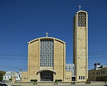
Title: St. Columba Catholic Cathedral in Youngstown, Ohio, which houses the seat of the Diocese of Youngstown.
Physical description: 1 photograph : digital, tiff file, color.
Notes: Purchase; Carol M. Highsmith Photography, Inc.; 2016; (DLC/PP-2016:103-4).; Forms part of: Carol M. Highsmith Archive.; Credit line: Photographs in the Carol M. Highsmith Archive, Library of Congress, Prints and Photographs Division.; Title, date and keywords based on information provided by the photographer.Autor:
- real name: Artur Jan Fijałkowski
- pl.wiki: WarX
- commons: WarX
- mail: [1]
- jabber: WarX@jabber.org
- irc: [2]
- software: own perl scripts
Piramida wieku dla hrabstwa Mahoning w stanie Ohio w USA na podstawie spisu ludności z 2000 roku
This is a locator map showing Mahoning County in Ohio. For more information, see Commons:United States county locator maps.


