Hrabstwo Maricopa
| hrabstwo | |||
 Budynek sądu hrabstwa Maricopa | |||
| |||
| Państwo | |||
|---|---|---|---|
| Stan | |||
| Siedziba | |||
| Kod statystyczny | FIPS 6-4: 04013 | ||
| Powierzchnia | 23 891 km²[1] | ||
| Populacja (2012) • liczba ludności |
| ||
| • gęstość | 153 os./km² | ||
| Strefa czasowa | |||
Położenie na mapie Arizona | |||
| 33°20′47,55″N 112°29′43,92″W/33,346542 -112,495533 | |||
| Strona internetowa | |||
| Portal | |||
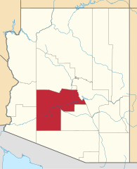
Hrabstwo Maricopa – hrabstwo w USA w południowo-zachodnio-centralnej części stanu Arizona. W lipcu 2010 roku liczba mieszkańców wyniosła 3 817 117[2] – najwięcej w całej Arizonie. Siedzibą władz jest Phoenix, będący także stolicą stanu.
Geografia
Całkowita powierzchnia wynosi 23 891 km² z tego 55 km² (0,23%) stanowi woda. Kilka rezerwatów Indian. M.in. Gila River Indian Community (na południe od Phoenix) i Salt River Pima Maricopa Indian Community (wschodnia część Scottsdale).
Wybrane miejscowości
- Apache Junction
- Avondale
- Buckeye
- Carefree
- Cave Creek
- Chandler
- El Mirage
- Fountain Hills
- Gila Bend
- Glendale
- Gilbert
- Goodyear
- Guadalupe
- Litchfield Park
- Mesa
- Phoenix
- Paradise Valley
- Peoria (fragment w hrabstwie Yavapai)
- Scottsdale
- Surprise
- St. Johns
- Tolleson
- Tempe
- Wickenburg
- Youngtown
CDP
- Aguila
- Anthem
- Arlington
- Citrus Park
- Gila Crossing
- New River
- Morristown
- Maricopa Colony
- Komatke
- Kaka
- Rio Verde
- St. Johns
- Sun City
- Sun City West
- Sun Lakes
- Tonopah
- Theba
- Wittmann
- Wintersburg
Sąsiednie hrabstwa
- hrabstwo La Paz – zachód
- hrabstwo Yuma – zachód
- hrabstwo Pima – południe
- hrabstwo Pinal – południowy wschód
- hrabstwo Gila – wschód
- hrabstwo Yavapai – północ
Przypisy
- ↑ Geography 2010 Census Gazetteer Files (ang.). United States Cenzus Bureau. [dostęp 2013-03-18].
- ↑ a b State & County QuickFacts - Maricopa County, Arizona (ang.). U.S. Census Bureau. [dostęp 2013-03-18].
Media użyte na tej stronie
The flag of Navassa Island is simply the United States flag. It does not have a "local" flag or "unofficial" flag; it is an uninhabited island. The version with a profile view was based on Flags of the World and as a fictional design has no status warranting a place on any Wiki. It was made up by a random person with no connection to the island, it has never flown on the island, and it has never received any sort of recognition or validation by any authority. The person quoted on that page has no authority to bestow a flag, "unofficial" or otherwise, on the island.
Autor: Ken Lund from Las Vegas, Nevada, USA, Licencja: CC BY-SA 2.0
Back Side of Maricopa County Courthouse, Phoenix, Arizona
Autor:
- real name: Artur Jan Fijałkowski
- pl.wiki: WarX
- commons: WarX
- mail: [1]
- jabber: WarX@jabber.org
- irc: [2]
- software: own perl scripts
Piramida wieku dla hrabstwa Maricopa w stanie Arizona w USA na podstawie spisu ludności z 2000 roku
Autor: Flagvisioner (SVG), CRW Flags (raster), Licencja: CC0
Flag of Maricopa County, Arizona


