Hrabstwo Navarro
| hrabstwo | |
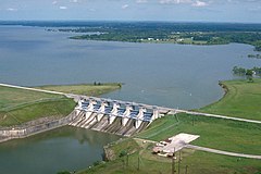
 Zapora na jeziorze Navarro Mills | |
| Państwo | |
|---|---|
| Stan | |
| Siedziba | |
| Powierzchnia | 2813 km² |
| Populacja (2020) • liczba ludności |
|
| • gęstość | 20 os./km² |
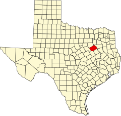
Położenie na mapie Teksas | |
| Strona internetowa | |
| Portal | |
Hrabstwo Navarro – hrabstwo położone w USA w stanie Teksas. Utworzone w 1846 r. Siedzibą hrabstwa jest miasto Corsicana.
Sąsiednie hrabstwa
- Hrabstwo Henderson (północny wschód)
- Hrabstwo Freestone (południowy wschód)
- Hrabstwo Limestone (południe)
- Hrabstwo Hill (południowy zachód)
- Hrabstwo Ellis (północny zachód)
Miasta
| ||
Demografia
W 2020 roku 81% mieszkańców hrabstwa stanowiła ludność biała (54,7% nie licząc Latynosów), 13,3% to byli czarnoskórzy Amerykanie lub Afroamerykanie, 2,1% było rasy mieszanej, 1,7% pochodziło z wysp Pacyfiku, 1,1% to rdzenna ludność Ameryki i 0,8% to byli Azjaci. Latynosi stanowili 28,5% ludności hrabstwa[1].
Religia
W 2010 roku w hrabstwie Navarro swoją działalność prowadzi wiele kościołów protestanckich (baptyści, metodyści, zielonoświątkowcy, campbellici i inni), które są główną siłą religijną w hrabstwie. Obecne były także niewielkie społeczności katolików (3,8%), mormonów (0,85%) i świadków Jehowy (1 zbór)[2].
Przypisy
- ↑ U.S. Census Bureau QuickFacts: Navarro County, Texas; Texas, www.census.gov [dostęp 2022-02-05] (ang.).
- ↑ Navarro County (Texas) - Religious Traditions, 2010, www.thearda.com [dostęp 2022-02-05].
Media użyte na tej stronie
The flag of Navassa Island is simply the United States flag. It does not have a "local" flag or "unofficial" flag; it is an uninhabited island. The version with a profile view was based on Flags of the World and as a fictional design has no status warranting a place on any Wiki. It was made up by a random person with no connection to the island, it has never flown on the island, and it has never received any sort of recognition or validation by any authority. The person quoted on that page has no authority to bestow a flag, "unofficial" or otherwise, on the island.
Aerial view of Navarro Mills Lake and Dam on Richland Creek in Navarro County, Texas, USA. The U.S. Army Corps of Engineers constructed this dam in 1963 for flood control and water supply for Navarro County. This concrete and earth-fill dam is about three-quarters of a mile (1 km) long, but this photograph shows only the central water-control structure of the dam. View is to the northwest.
This is a locator map showing Navarro County in Texas. For more information, see Commons:United States county locator maps.
Autor:
- real name: Artur Jan Fijałkowski
- pl.wiki: WarX
- commons: WarX
- mail: [1]
- jabber: WarX@jabber.org
- irc: [2]
- software: own perl scripts
Piramida wieku dla hrabstwa Navarro w stanie Teksas w USA na podstawie spisu ludności z 2000 roku


