Hrabstwo Newaygo
| hrabstwo | |
 | |
| Państwo | |
|---|---|
| Stan | |
| Siedziba | White Cloud |
| Kod statystyczny | FIPS 6-4: 26123 |
| Powierzchnia | 2 231,01 km²[1] |
| Populacja (2010) • liczba ludności |
|
| • gęstość | 22,21 os./km² |
| Strefa czasowa | UTC-5/-4 |
Położenie na mapie Michigan | |
| 43°33′45,75″N 85°47′29,12″W/43,562708 -85,791422 | |
| Portal | |
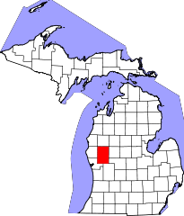
Hrabstwo Newaygo (ang. Newaygo County) – hrabstwo w stanie Michigan w Stanach Zjednoczonych. Obszar całkowity hrabstwa obejmuje powierzchnię 861,39 mil2 (2 231,01 km2). Według danych z 2010 r. hrabstwo miało 48 460 mieszkańców[2]. Hrabstwo powstało w 1840 roku i nosi imię indiańskiego wodza plemienia Czipejów, który był sygnatariuszem traktatu z Saginaw w 1819 roku.
Sąsiednie hrabstwa
- Hrabstwo Lake (północ)
- Hrabstwo Osceola (północny wschód)
- Hrabstwo Mecosta (wschód)
- Hrabstwo Montcalm (południowy wschód)
- Hrabstwo Kent (południe)
- Hrabstwo Muskegon (południowy zachód)
- Hrabstwo Oceana (zachód)
- Hrabstwo Mason (północny zachód)
Miasta
- Fremont
- Grant
- Newaygo
- White Cloud
Wioski
- Hesperia
Przypisy
- ↑ Census 2000 U.S. Gazetteer Files: Counties (ang.). [dostęp 2013-07-28].
- ↑ QuickFacts from the US Census Bureau (ang.). [dostęp 2013-07-28].
Media użyte na tej stronie
The flag of Navassa Island is simply the United States flag. It does not have a "local" flag or "unofficial" flag; it is an uninhabited island. The version with a profile view was based on Flags of the World and as a fictional design has no status warranting a place on any Wiki. It was made up by a random person with no connection to the island, it has never flown on the island, and it has never received any sort of recognition or validation by any authority. The person quoted on that page has no authority to bestow a flag, "unofficial" or otherwise, on the island.
Autor: Brian from Michigan, USA ... uploaded by User:Lar, Licencja: CC BY 2.0
(by Brian.H, from the Flickr page)
- Combo of three handheld images. The left-hand side of this shows where the s/w couldn't match everything up quite right. I really have to remember to throw my tripod in the car! At least I don't forget the camera when I leave the house :)
- From the historical marker: The Croton Hydroelectric Generating Dam began operation in 1907. It is capable of generating 8,800 kilowatts of electricity, enough to serve a community of about 4,900 people. The plant is located in Newaygo County’s Croton Township.
(by user:Lar)
- Croton Dam is a dam and powerplant complex on the Muskegon River in Croton Township, Newaygo County, Michigan, operated by Consumers Energy. This composite was created from images taken from the downstream side, to the SE of the powerhouse. This image is near the E end of the dam, at location A on the locator, facing NW
This is a locator map showing Newaygo County in Michigan. For more information, see Commons:United States county locator maps.


