Hrabstwo Richland (Dakota Północna)
| hrabstwo | |
 | |
| Państwo | |
|---|---|
| Stan | |
| Siedziba | Wahpeton |
| Kod statystyczny | FIPS 6-4: 38077 |
| Powierzchnia | 3 745 km² |
| Populacja (2000) • liczba ludności | 17 998 |
| • gęstość | 5 os./km² |
Położenie na mapie Nevada | |
| Portal | |
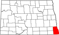
Hrabstwo Richland - amerykańskie hrabstwo w południowo-wschodniej części stanu Dakota Północna. W roku 2000, liczba mieszkańców wyniosła 17 998. Stolicą jest Wahpeton.
Historia
Powstało 4 stycznia 1873 roku, ale władze zorganizowały się dopiero 25 listopada. Nazwano na cześć Morgana T. Richa (1832-1898) - jednego z pierwszych osadników. Stolicą hrabstwa zostało Chahinkapa, którego nazwę zmieniono niedługo później na Wahpeton. Najwyższą populację osiągnął w 1930 roku.
Geografia
Całkowita powierzchnia wynosi 3 744 km². Z tego 23 km² (0.62%) stanowi woda.
Miasta
|
|
Gminy
|
|
|
Autostrady
 Międzystanowa nr 29
- Stanowa nr 11
- Stanowa nr 13
- Stanowa nr 18
- Stanowa nr 27
- Stanowa nr 46
- Stanowa nr 127
Sąsiednie hrabstwa
- Cass - północ
- Wilkin w Minnesocie - wschód
- Traverse w Minnesocie - południowy wschód
- Roberts w Dakocie Południowej -południe
- Sargent - zachód
- Ransom - zachód
Bibliografia
Media użyte na tej stronie
The flag of Navassa Island is simply the United States flag. It does not have a "local" flag or "unofficial" flag; it is an uninhabited island. The version with a profile view was based on Flags of the World and as a fictional design has no status warranting a place on any Wiki. It was made up by a random person with no connection to the island, it has never flown on the island, and it has never received any sort of recognition or validation by any authority. The person quoted on that page has no authority to bestow a flag, "unofficial" or otherwise, on the island.
Autor: Tim Kiser (w:User:Malepheasant), Licencja: CC BY-SA 2.5
The Richland County Courthouse in w:Wahpeton, North Dakota
Flag of the State of Nevada. The flag is described in Nevada Revised Statutes Chapter 235, Sec. 20 as follows: The body of the flag must be of solid cobalt blue. On the field in the upper left quarter thereof must be two sprays of Sagebrush with the stems crossed at the bottom to form a half wreath. Within the sprays must be a five-pointed silver star with one point up. The word “Nevada” must also be inscribed below the star and above the sprays, in a semicircular pattern with the letters spaced apart in equal increments, in the same style of letters as the words “Battle Born.” Above the wreath, and touching the tips thereof, must be a scroll bearing the words “Battle Born.” The scroll and the word “Nevada” must be golden-yellow. The lettering on the scroll must be black-colored sans serif gothic capital letters.
Autor:
- real name: Artur Jan Fijałkowski
- pl.wiki: WarX
- commons: WarX
- mail: [1]
- jabber: WarX@jabber.org
- irc: [2]
- software: own perl scripts
Piramida wieku dla hrabstwa Richland w stanie Dakota Północna w USA na podstawie spisu ludności z 2000 roku
This is a locator map showing Richland County in North Dakota. For more information, see Commons:United States county locator maps.


