Hrabstwo Santa Cruz (Arizona)
| hrabstwo | |
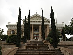
 Budynek sądu hrabstwa Santa Cruz | |
| Państwo | |
|---|---|
| Stan | |
| Siedziba | |
| Kod statystyczny | FIPS 6-4: 04023 |
| Powierzchnia | 3207 km²[1] |
| Populacja (2012) • liczba ludności |
|
| Strefa czasowa | |
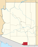
Położenie na mapie Arizona | |
| 31°31′32,25″N 110°50′42,58″W/31,525625 -110,845161 | |
| Strona internetowa | |
| Portal | |
Hrabstwo Santa Cruz – hrabstwo w Stanach Zjednoczonych, w południowej części stanu Arizona. W roku 2010 liczba mieszkańców wyniosła 47 420[2]. Stolicą jest Nogales.
Historia
Hrabstwo Santa Cruz (hiszp. święty krzyż) powstało w 1899 roku. Nazwa pochodzi od rzeki Santa Cruz, której nazwę nadał jezuicki misjonarz Eusebio Kino pod koniec XVII wieku.
Geografia
Całkowita powierzchnia wynosi 3 207 km² co sprawia, że jest to najmniejsze hrabstwo w Arizonie[1]. Na terenie hrabstwa leżą Narodowy Park Historyczny Tumacácori, Coronado National Forest (część) i Las Cienegas National Conservation Area (część).
Miejscowości
CDP
- Amado
- Beyerville
- Elgin
- Kino Springs
- Rio Rico
- Sonoita
- Tubac
- Tumacacori-Carmen
Sąsiednie hrabstwa
- hrabstwo Pima – zachód i północ
- hrabstwo Cochise – wschód
- gmina Nogales w meksykańskim stanie Sonora – południowy zachód
- gmina Santa Cruz w meksykańskim stanie Sonora – południe
- gmina Sáric w meksykańskim stanie Sonora – południowy wschód
Przypisy
- ↑ a b Geography 2010 Census Gazetteer Files (ang.). United States Cenzus Bureau. [dostęp 2013-03-18].
- ↑ a b State & County QuickFacts - Santa Cruz County, Arizona (ang.). U.S. Census Bureau. [dostęp 2013-03-18].
Media użyte na tej stronie
The flag of Navassa Island is simply the United States flag. It does not have a "local" flag or "unofficial" flag; it is an uninhabited island. The version with a profile view was based on Flags of the World and as a fictional design has no status warranting a place on any Wiki. It was made up by a random person with no connection to the island, it has never flown on the island, and it has never received any sort of recognition or validation by any authority. The person quoted on that page has no authority to bestow a flag, "unofficial" or otherwise, on the island.
Locator map of Santa Cruz County in southern Arizona.
Autor: Ken Lund, Licencja: CC BY-SA 2.0
Front of the Santa Cruz County Courthouse, located at the intersection of Court and Morley Streets in downtown Nogales, Arizona, United States. Built in 1903, the courthouse is listed on the National Register of Historic Places.
Autor:
- real name: Artur Jan Fijałkowski
- pl.wiki: WarX
- commons: WarX
- mail: [1]
- jabber: WarX@jabber.org
- irc: [2]
- software: own perl scripts
Piramida wieku dla hrabstwa Santa Cruz w stanie Arizona w USA na podstawie spisu ludności z 2000 roku


