Hrabstwo St. Joseph (Michigan)
| hrabstwo | |
 | |
| Państwo | |
|---|---|
| Stan | |
| Siedziba | Centreville |
| Kod statystyczny | FIPS 6-4: 26149 |
| Powierzchnia | 1 349,79 km²[1] |
| Populacja (2010) • liczba ludności |
|
| • gęstość | 46,98 os./km² |
| Strefa czasowa | UTC-5/-4 |
Położenie na mapie Michigan | |
| 41°54′41,36″N 85°31′22,33″W/41,911489 -85,522869 | |
| Portal | |
Hrabstwo St. Joseph (ang. St. Joseph County, Saint Joseph County) – hrabstwo w stanie Michigan w Stanach Zjednoczonych. Obszar całkowity hrabstwa obejmuje powierzchnię 521,15 mil2 (1 349,79 km2). Według danych z 2010 r. hrabstwo miało 61 295 mieszkańców[2]. Hrabstwo powstało w 1829 roku, a jego nazwa pochodzi od patrona Nowej Francji - św. Józefa.
Sąsiednie hrabstwa
- Hrabstwo Kalamazoo (północ)
- Hrabstwo Calhoun (północny wschód)
- Hrabstwo Branch (wschód)
- Hrabstwo LaGrange (Indiana) (południe)
- Hrabstwo Elkhart (Indiana) (południowy zachód)
- Hrabstwo Cass (zachód)
- Hrabstwo Van Buren (północny zachód)
Miasta i miejscowości
Wioski
- Burr Oak
- Centreville
- Colon
- Constantine
- Mendon
- White Pigeon
Demografia
Historia populacji Hrabstwa Saint Joseph w latach 1830 - 2010
Linki zewnętrzne
- American FactFinder (ang.). [dostęp 2012-06-29]. [zarchiwizowane z tego adresu (2019-05-21)].
Przypisy
- ↑ Census 2000 U.S. Gazetteer Files: Counties (ang.). [dostęp 2013-07-21].
- ↑ QuickFacts from the US Census Bureau (ang.). [dostęp 2013-07-21].
Media użyte na tej stronie
The flag of Navassa Island is simply the United States flag. It does not have a "local" flag or "unofficial" flag; it is an uninhabited island. The version with a profile view was based on Flags of the World and as a fictional design has no status warranting a place on any Wiki. It was made up by a random person with no connection to the island, it has never flown on the island, and it has never received any sort of recognition or validation by any authority. The person quoted on that page has no authority to bestow a flag, "unofficial" or otherwise, on the island.
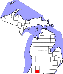
This is a locator map showing Saint Joseph County in Michigan. For more information, see Commons:United States county locator maps.
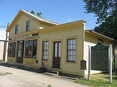
Front and western side of the Old US Government Land Office Building, located at 113 W. Chicago Road (U.S. Route 12) in White Pigeon, Michigan, United States. Built in 1831, it is Michigan's oldest extant federal land office and one of just a few remaining throughout the former Northwest Territory. It is listed on the National Register of Historic Places.


