Hrabstwo St. Mary’s
| hrabstwo | |||||
 | |||||
| Państwo | |||||
|---|---|---|---|---|---|
| Stan | |||||
| Siedziba | Leonardtown | ||||
| Kod statystyczny | FIPS 6-4: 24037 | ||||
| Powierzchnia | 1 980 km² | ||||
| Populacja (2000) • liczba ludności | 86 211 | ||||
| • gęstość | 92 os./km² | ||||
| Strefa czasowa | UTC -5:00/-4:00 | ||||
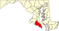
Położenie na mapie Maryland | |||||
| Strona internetowa | |||||
| Portal | |||||
Hrabstwo Saint Mary's (ang. Saint Mary's County) to hrabstwo w stanie Maryland w Stanach Zjednoczonych. Hrabstwo zajmuje powierzchnię całkowitą 1 982 km²[1] i według szacunków US Census Bureau w roku 2006 liczyło 98 854 mieszkańców.[2] Siedzibą hrabstwa jest miasto Leonardtown.
Historia
Hrabstwo Saint Mary's było pierwszym hrabstwem w Maryland. Pierwsza wzmianka o nim pochodzi z roku 1637, kiedy zostało prawdopodobnie ustanowione decyzją ówczesnego gubernatora, Leonarda Calverta. Nazwa hrabstwa, która po polsku znaczy hrabstwo świętej Marii, pochodzi od Marii z Nazaretu, matki Jezusa.[3]
Geografia
Całkowita powierzchnia hrabstwa wynosi 1 980 km², z czego 936 km² stanowi powierzchnia lądowa, a 1 044 km² (52,7%) powierzchnia wodna.
Miasta
- Leonardtown
CDP
- California
- Charlotte Hall
- Golden Beach
- Lexington Park
- Mechanicsville
- Piney Point
- St. George Island
- Tall Timbers
Przypisy
- ↑ Podstawowe dane demograficzne dotyczące hrabstw w stanie Maryland US Census Bureau
- ↑ Maryland population estimates by county US Census Bureau
- ↑ Profil Saint Mary's County Maryland State Archives
Media użyte na tej stronie
The flag of Navassa Island is simply the United States flag. It does not have a "local" flag or "unofficial" flag; it is an uninhabited island. The version with a profile view was based on Flags of the World and as a fictional design has no status warranting a place on any Wiki. It was made up by a random person with no connection to the island, it has never flown on the island, and it has never received any sort of recognition or validation by any authority. The person quoted on that page has no authority to bestow a flag, "unofficial" or otherwise, on the island.
This is a locator map showing Saint Mary's County in Maryland. For more information, see Commons:United States county locator maps.
Rebuilt Blackistone Lighthouse, September 2009
Flag of St. Mary's County, Maryland
Autor:
- real name: Artur Jan Fijałkowski
- pl.wiki: WarX
- commons: WarX
- mail: [1]
- jabber: WarX@jabber.org
- irc: [2]
- software: own perl scripts
Piramida wieku dla hrabstwa St. Mary's w stanie Maryland w USA na podstawie spisu ludności z 2000 roku


