Hrabstwo Uintah
| hrabstwo | |
 | |
| Państwo | |
|---|---|
| Stan | |
| Siedziba | |
| Kod statystyczny | FIPS 6-4: 49047 |
| Powierzchnia | 11 652 km²[1] |
| Populacja (2009) • liczba ludności |
|
| • gęstość | 5,6 os./km² |
| Strefa czasowa | |
Położenie na mapie Utah | |
| 40°07′48″N 109°31′12″W/40,130000 -109,520000 | |
| Strona internetowa | |
| Portal | |
Hrabstwo Uintah (ang. Uintah County) – hrabstwo w stanie Utah w Stanach Zjednoczonych. Siedzibą hrabstwa (a zarazem jego największym miastem) jest Vernal.
Miasta
- Ballard
- Naples
- Vernal
CDP
- Bonanza
- Fort Duchesne
- Jensen
- Maeser
- Randlett
- Whiterocks
Przypisy
- ↑ US Census Bureau: Uintah County. Population, Housing Units, Area, and Density: 2000 (ang.). [dostęp 2011-01-01].
- ↑ US Census Bureau: Uintah County (ang.). Quickfacts. [dostęp 2011-01-01].
Media użyte na tej stronie
The flag of Navassa Island is simply the United States flag. It does not have a "local" flag or "unofficial" flag; it is an uninhabited island. The version with a profile view was based on Flags of the World and as a fictional design has no status warranting a place on any Wiki. It was made up by a random person with no connection to the island, it has never flown on the island, and it has never received any sort of recognition or validation by any authority. The person quoted on that page has no authority to bestow a flag, "unofficial" or otherwise, on the island.
Flag of Utah. Please do not revert to the "21:58, July 26, 2011" or any earlier version, as those versions are factually inaccurate.
Autor: InSapphoWeTrust from Los Angeles, California, USA, Licencja: CC BY-SA 2.0
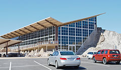
Dinosaur National Monument is located along the Utah-Colorado border. The Utah portion, located just outside Jensen, is home to the famous quarry where a large number of dinosaur bones were found and are still on display.
This is the structure that covers and protects the open quarry. It had first been built in the 1950s, but thanks to improper design that did not take the geology of the soil into consideration, the building immediately started cracking and tilting. It was completely closed in 2006, demolished, and rebuilt into its current form with the American Recovery and Reinvestment Act funds from 2009; it re-opened in October 2011, and the visitor center, formerly here in a cylindrical building, was moved half a mile downhill into a brand-new building.
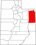
The silver Hyundai Genesis is my car - a LONG way from home.This is a locator map showing Uintah County in Utah. For more information, see Commons:United States county locator maps.
Autor:
- real name: Artur Jan Fijałkowski
- pl.wiki: WarX
- commons: WarX
- mail: [1]
- jabber: WarX@jabber.org
- irc: [2]
- software: own perl scripts
Piramida wieku dla hrabstwa Uintah w stanie Utah w USA na podstawie spisu ludności z 2000 roku


