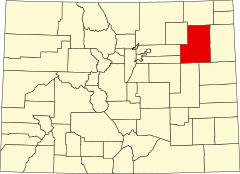
Hrabstwo Washington (Kolorado)
| hrabstwo | |
 Miejscowość Cope. | |
| Państwo | |
|---|---|
| Stan | |
| Siedziba | Akron |
| Kod statystyczny | FIPS 6-4: 08121 |
| Powierzchnia | 6 536,91 km²[1] |
| Populacja (2020) • liczba ludności |
|
| • gęstość | 0,7 os./km² |
| Strefa czasowa | UTC-7/-6 |
Położenie na mapie Kolorado | |
| 39°57′55,487″N 103°12′34,578″W/39,965413 -103,209605 | |
| Portal | |
Hrabstwo Washington (ang. Washington County) – hrabstwo w stanie Kolorado w Stanach Zjednoczonych. Hrabstwo powstało 9 lutego 1887 roku i nosi imię Jerzego Waszyngtona, który był pierwszym prezydentem Stanów Zjednoczonych. Siedzibą hrabstwa jest Akron.
Demografia
Według spisu w 2020 roku liczy ponad 4,8 tys. mieszkańców, w tym 95,7% to biali. Latynosi to zaledwie 10,9% populacji, znacznie poniżej średniej stanowej[2].
Pod względem religijnym w 2010 roku największą grupę stanowią osoby niestowarzyszone w żadnym związku wyznaniowym. Ponadto religijność hrabstwa zdominowana jest przez protestantów (24,0%) i katolików (13,3%)[3]. Hrabstwo Washington posiada najwyższy odsetek zielonoświątkowców (6,6%) w stanie Kolorado[4].
Sąsiednie hrabstwa
- Hrabstwo Logan (północ)
- Hrabstwo Yuma (wschód)
- Hrabstwo Kit Carson (południowy wschód)
- Hrabstwo Lincoln (południe)
- Hrabstwo Arapahoe (zachód)
- Hrabstwo Adams (zachód)
- Hrabstwo Morgan (północny zachód)
Miasta
- Akron
- Otis
Przypisy
- ↑ Census 2000 U.S. Gazetteer Files: Counties (ang.). [dostęp 2013-08-29].
- ↑ U.S. Census Bureau QuickFacts: Washington County, Colorado; United States, www.census.gov [dostęp 2022-02-01] (ang.).
- ↑ Washington County (Colorado) - Religious Traditions, 2010, www.thearda.com [dostęp 2022-02-01].
- ↑ Pentecostal Counties (2010) | QuickLists | The Association of Religion Data Archives, www.thearda.com [dostęp 2022-02-01].
Media użyte na tej stronie
The flag of Navassa Island is simply the United States flag. It does not have a "local" flag or "unofficial" flag; it is an uninhabited island. The version with a profile view was based on Flags of the World and as a fictional design has no status warranting a place on any Wiki. It was made up by a random person with no connection to the island, it has never flown on the island, and it has never received any sort of recognition or validation by any authority. The person quoted on that page has no authority to bestow a flag, "unofficial" or otherwise, on the island.
Autor: Jeffrey Beall, Licencja: CC BY 4.0
Cope, Colorado, an unincorporated community in Washington County. The road in the picture is U.S. Route 36.
A map of Colorado highlighting Washington County. For more information, see Commons:United States county locator maps.


