Hrabstwo White Pine
| ||||
| ||||
 Budynek sądu hrabstwa White Pine w Ely | ||||
| Państwo | ||||
| Stan | ||||
| Siedziba | Ely | |||
| Kod statystyczny | FIPS 6-4: 32033 | |||
| Powierzchnia | 23 042 km² | |||
| Populacja (2010) • liczba ludności | 10026[1]. | |||
Położenie na mapie Nevada | ||||
| Strona internetowa | ||||
| Portal | ||||
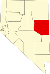
Hrabstwo White Pine – amerykańskie hrabstwo w środkowo-wschodniej części stanu Nevada. W roku 2000 liczba ludności wynosiła 9181. Stolicą jest Ely.
Historia
White Pine powstało w 1869 roku poprzez oderwanie się wschodnich terenów hrabstwa Lander. Nazwa wywodzi się od sosny zachodniej (ang. White Pine), popularnego drzewa w miejscowych górach. Pierwszą stolicą było Hamilton. W 1887 roku władze przeniosły się do Ely, gdyż poprzednią siedzibę strawił pożar.
Geografia
Całkowita powierzchnia wynosi 23 042 km² (8897 mil²), z czego 22 989 km² (8 876 mil²) stanowi ląd, a 53 km² (21 mil², 0,23%) woda.
Znajdują się tutaj niektóre odcinki Narodowego Lasu Humboldt-Toiyabe. Zarządza nimi Stanowy Park Historyczny Piece Węgla Drzewnego.
W południowo-wschodniej części hrabstwa znajduje się Park Narodowy Wielkiej Kotliny[2].
Miasta
CDP
Sąsiednie hrabstwa
- Hrabstwo Elko – północ
- Hrabstwo Eureka – zachód
- Hrabstwo Nye – południowy zachód
- Hrabstwo Lincoln – południe
- Hrabstwo Millard w Utah – wschód
- Hrabstwo Juab w Utah – wschód
- Hrabstwo Tooele w Utah – północny wschód
Gospodarka
Od końca XIX wieku do lat dziewięćdziesiątych XX wieku, największy w regionie przemysł wydobywczy złota, srebra i miedzi. Najwięcej zysków przynosiły kopalnie odkrywkowe w pobliżu miast Ruth i McGill kierowanych przez Kennecott Utah Copper Corporation.
Linki zewnętrzne
Przypisy
- ↑ QuickFacts, White Pine County, Nevada (ang.). US Census, U.S. Department of Commerce. [dostęp 2019-08-17].
- ↑ Feature Detail Report for: Great Basin National Park (ang.). U.S. Department of the Interior, U.S. Geological Survey. [dostęp 2019-08-17].
Media użyte na tej stronie
The flag of Navassa Island is simply the United States flag. It does not have a "local" flag or "unofficial" flag; it is an uninhabited island. The version with a profile view was based on Flags of the World and as a fictional design has no status warranting a place on any Wiki. It was made up by a random person with no connection to the island, it has never flown on the island, and it has never received any sort of recognition or validation by any authority. The person quoted on that page has no authority to bestow a flag, "unofficial" or otherwise, on the island.
Autor:
- real name: Artur Jan Fijałkowski
- pl.wiki: WarX
- commons: WarX
- mail: [1]
- jabber: WarX@jabber.org
- irc: [2]
- software: own perl scripts
Piramida wieku dla hrabstwa White Pine w stanie Nevada w USA na podstawie spisu ludności z 2000 roku
Autor: Finetooth, Licencja: CC BY-SA 3.0
White Pine County Courthouse in Ely, Nevada, in the United States
This is a locator map showing White Pine County in Nevada. For more information, see Commons:United States county locator maps.
Flag of the State of Nevada. The flag is described in Nevada Revised Statutes Chapter 235, Sec. 20 as follows: The body of the flag must be of solid cobalt blue. On the field in the upper left quarter thereof must be two sprays of Sagebrush with the stems crossed at the bottom to form a half wreath. Within the sprays must be a five-pointed silver star with one point up. The word “Nevada” must also be inscribed below the star and above the sprays, in a semicircular pattern with the letters spaced apart in equal increments, in the same style of letters as the words “Battle Born.” Above the wreath, and touching the tips thereof, must be a scroll bearing the words “Battle Born.” The scroll and the word “Nevada” must be golden-yellow. The lettering on the scroll must be black-colored sans serif gothic capital letters.


