Huntingdonshire
| dystrykt niemetropolitalny | |||||
 A14, Huntingdon | |||||
| |||||
| Państwo | |||||
|---|---|---|---|---|---|
| Kraj | |||||
| Region | |||||
| Hrabstwo | |||||
| Siedziba | |||||
| Powierzchnia | 912,5 km² | ||||
| Populacja (2011) • liczba ludności |
| ||||
| • gęstość | 190 os./km² | ||||
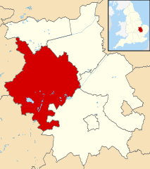
| Położenie na mapie Cambridgeshire Contains Ordnance Survey data © Crown copyright and database right, CC BY-SA 3.0 | |||||
| Strona internetowa | |||||
| Portal | |||||
Huntingdonshire – dystrykt w hrabstwie Cambridgeshire oraz historyczne hrabstwo w Anglii. W 2011 roku dystrykt liczył 169 508 mieszkańców[1].
Miasta
Inne miejscowości
Abbots Ripton, Abbotsley, Alconbury, Alconbury Weston, Alwalton, Barham and Woolley, Barham, Bluntisham, Brampton, Brington, Broughton, Buckden, Buckworth, Bury, Bythorn, Bythorn and Keyston, Caldecote, Catworth, Chesterton, Colne, Conington, Coppingford, Covington, Denton, Diddington, Earith, Easton, Eaton Socon, Ellington, Elton, Eynesbury, Farcet, Fenstanton, Folksworth, Glatton, Grafham, Great Gidding, Great Gransden, Great Paxton, Great Staughton, Great Stukeley, Haddon, Hail Weston, Hamerton, Hartford, Hemingford Abbots, Hemingford Grey, Holme, Holywell, Houghton, Keyston, Kimbolton, Kings Ripton, Leighton Bromswold, Little Gidding, Little Paxton, Little Stukeley, Morborne, Needingworth, Offord D'Arcy, Old Hurst, Old Weston, Perry, Pidley, Ramsey Heights, Ramsey Mereside, Ramsey St Mary’s, Sawtry, Sibson, Sibson-cum-Stibbington, Somersham, Southoe, Southoe and Midloe, Spaldwick, Stibbington, Stilton, Stow Longa, Tetworth, The Offords, The Raveleys, The Stukeleys, Tilbrook, Upwood, Warboys, Waresley, Water Newton, Winwick, Wistow, Woodhurst, Wood Walton, Woolley, Yaxley, Yelling.
Przypisy
- ↑ Area: Huntingdonshire (Local Authority) (ang.). Neighbourhood Statistics (ONS). [dostęp 2016-05-06]. [zarchiwizowane z tego adresu (2016-10-10)].
Media użyte na tej stronie
Flag of England. Saint George's cross (a red cross on a white background), used as the Flag of England, the Italian city of Genoa and various other places.
Contains Ordnance Survey data © Crown copyright and database right, CC BY-SA 3.0
Map of Cambridgeshire, UK with Huntingdonshire highlighted.
Equirectangular map projection on WGS 84 datum, with N/S stretched 160%Autor: Zacwill16, Licencja: CC BY-SA 4.0
Coat of arms of the English county of Huntingdonshire, granted in 1937. Blazon: Barry wavy argent and azure, a lozenge throughout vert charged with a fess embattled on the upper side between in chief three garbs one and two and in base a cornucopia Or.
The county flag of Huntingdonshire


