Huragan Hanna (2008)
| Huragan 1 kategorii w skali Saffira-Simpsona | |
 Huragan Hanna | |
| Typ | |
|---|---|
| Początek | |
| Koniec | |
| Najwyższa prędkość wiatru | 140 km/h |
| Najniższe ciśnienie | 977 hPa |
| Ofiary śmiertelne | 537 osób |
| Zaginieni | 13 osób |
| Straty materialne | ~160 mln USD |
| Dotknięte kraje | Stany Zjednoczone, Haiti, wyspy karaibskie |
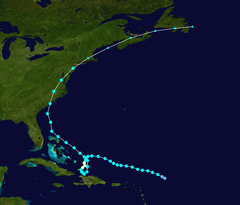
 Trasa przejścia Hanny | |
Huragan Hanna – cyklon tropikalny, który nad ranem 6 września 2008 zagroził atlantyckiemu wybrzeżu amerykańskich stanów Karolina Południowa, Karolina Północna, Wirginia, po uderzeniu w Haiti.

Huragan Hanna powstał 28 sierpnia 2008 ENE od Wysp Nawietrznych na Morzu Karaibskim. Wskutek jego nadejścia zginęło 537 osób, a trzynaście uznaje się za zaginionych, głównie w Gonaives i okolicach Haiti (stan z 6 września 2008). Fala powodziowa zatopiła niektóre ulice na głębokość pięciu metrów.
Hanna to ósmy sztorm z nazwą własną, czwarty huragan na Atlantyku w roku 2008. Przechodząc 330 km na wschód od stolicy Bahamów, Nassau, huragan osłabł nieznacznie nad wodami na wschód od Florydy, przechodząc z I kategorii na skali Saffira-Simpsona do rangi sztormu tropikalnego. Zmierzał płaskim łukiem w kierunku północno-wschodnim wzdłuż Wybrzeża Atlantyckiego, po najściu obu Karolin pomiędzy Myrtle Beach i Wilmington (Karolina Północna) o 03:20 czasu lokalnego. Spodziewane ponowne wzmocnienie z powrotem do rangi huraganu nie nastąpiło. Pomimo jego wielkiej rozległości obszarowo (burza o średnicy ponad 330 km), jako szybko przemieszczający się sztorm został oceniony jako stosunkowo mało groźny powodziowo dla USA i Kanady, natomiast potencjalnie katastrofalny pod względem erozji plaży.
Ofiary
| Kraj | Ofiary śmiertelne |
|---|---|
| 529 | |
| 7 | |
| 1 | |
| Razem: | 537 |
Linki zewnętrzne
Media użyte na tej stronie
The national and official state flag of Haiti; arms obtained from http://www.webchantier.com/. The civil flag can be found at here.
The flag of Navassa Island is simply the United States flag. It does not have a "local" flag or "unofficial" flag; it is an uninhabited island. The version with a profile view was based on Flags of the World and as a fictional design has no status warranting a place on any Wiki. It was made up by a random person with no connection to the island, it has never flown on the island, and it has never received any sort of recognition or validation by any authority. The person quoted on that page has no authority to bestow a flag, "unofficial" or otherwise, on the island.
The flag of the Dominican Republic has a centered white cross that extends to the edges. This emblem is similar to the flag design and shows a bible, a cross of gold and 6 Dominican flags. There are branches of olive and palm around the shield and above on the ribbon is the motto "Dios,Patria!, Libertad" ("God, Country, Freedom") and to amiable freedom. The blue is said to stand for liberty, red for the fire and blood of the independence struggle and the white cross symbolized that God has not forgotten his people. "Republica Dominicana". The Dominican flag was designed by Juan Pablo Duarte, father of the national Independence of Dominican Republic. The first dominican flag was sewn by a young lady named Concepción Bona, who lived across the street of El Baluarte, monument where the patriots gathered to fight for the independence, the night of February 27th, 1844. Concepción Bona was helped by her first cousin María de Jesús Pina.
Track map of Hurricane Hanna of the 2008 Atlantic hurricane season. The points show the location of the storm at 6-hour intervals. The colour represents the storm's maximum sustained wind speeds as classified in the Saffir–Simpson scale (see below), and the shape of the data points represent the nature of the storm, according to the legend below.
Storm type
Hurricane Hanna in the Atlantic ocean on September 1, 2008.


