Huragan Harvey
| Huragan 4. kategorii w skali Saffira-Simpsona | |
 Huragan Harvey przed uderzeniem w Teksas (25 sierpnia 2017) | |
| Typ | |
|---|---|
| Początek | 17 sierpnia 2017 |
| Koniec | 2 września 2017 |
| Najwyższa prędkość wiatru | 215 km/h |
| Najniższe ciśnienie | 938 hPa |
| Ofiary śmiertelne | przynajmniej 70 osób[1] osób[1] |
| Straty materialne | |
| Dotknięte kraje | |
 Mapa intensywności opadów spowodowanych przez Harvey | |
Huragan Harvey – największy od 2005 huragan nad terytorium Stanów Zjednoczonych[3]. To ósmy cyklon tropikalny o nazwie własnej w rejonie Północnego Atlantyku[a] i pierwszy huragan co najmniej 4. kategorii w 2017 roku w tym rejonie. Podczas 4 dni we wschodnim Teksasie, w rejonie miasta Houston, spadło ponad 1000 mm deszczu, co spowodowało olbrzymie powodzie. Szczytowa akumulacja wody na poziomie 1318 mm ustanowiła Harvey najbardziej mokrym cyklonem tropikalnym w historii Stanów Zjednoczonych.
Straty
Harvey był huraganem, który wyrządził najdotkliwsze w historii USA straty materialne (ponad 150 miliardów USD)[2]. Powódź dotknęła setki tysięcy gospodarstw domowych i zmusiła do opuszczenia domostw ponad 30 tys. osób. Harvey spowodował śmierć 107 osób[1].
Klasyfikacja
Harvey został zaklasyfikowany do 4. kategorii w Skali Saffira-Simpsona.
Galeria

Powódź w Teksasie (31 sierpnia 2017)
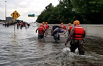
Żołnierze z Texas Army National Guard idą przez zalane ulice Houston

Zniszczona marina w Rockport
Zobacz też
Uwagi
- ↑ Wynika to z przyjętego nazewnictwa. Pierwszy cyklon w danym roku nosi imię na literę A, drugi na B, itd. Patrz: Listy nazw cyklonów tropikalnych.
Przypisy
- ↑ a b c Hurricane Harvey Death Toll Hits 70 - NBC 5 Dallas-Fort Worth, www.nbcdfw.com [dostęp 2017-11-18] (ang.).
- ↑ a b Huragan Harvey najdroższą katastrofą naturalną w historii USA - Gospodarka - polskieradio.pl, www.polskieradio.pl [dostęp 2017-11-18].
- ↑ Wyborcza.pl, wyborcza.pl [dostęp 2017-11-18].
Media użyte na tej stronie
_170828-Z-FG822-026_(36127995543).jpg)
Damage caused by Hurricane Harvey is seen at Rockport, Texas, Aug. 28, 2017. Hurricane Harvey formed in the Gulf of Mexico and made landfall in southeastern Texas, bringing record flooding and destruction to the region. U.S. military assets supported FEMA as well as state and local authorities in rescue and relief efforts. (U.S. Army National Guard photo by Sgt. 1st Class Malcolm McClendon) www.dvidshub.net
.jpg)
* #Harvey - still a menace! Hearts & prayers go out to families, friends, & fellow Texans dealing with this storm. #TexasStrong #HoustonStrong
- As Tropical Storm Harvey continues along the Gulf Coast, NASA has canceled a planned Aug. 30 question and answer session with astronaut Peggy Whitson aboard the International Space Station. NASA astronaut Randy Bresnik took this photo of the storm Aug. 28 from the orbiting laboratory.
_(50).jpg)
Members of the South Carolina's Helicopter Aquatic Rescue Team (SC-HART) perform rescue operations in Port Arthur, Texas, August 31, 2017. The SC-HART team consists of a UH-60 Black Hawk helicopter from the South Carolina Army National Guard with four Soldiers who are partnered with three rescue swimmers from the State Task Force and provide hoist rescue capabilities. Multiple states and agencies nationwide were called to assist citizens impacted by the epic amount of rainfall in Texas and Louisiana from Hurricane Harvey. (U.S. Air National Guard photo by Staff Sgt. Daniel J. Martinez)
5-day rainfall totals from Hurricane Harvey at 6am CDT August 30

Soldiers with the Texas Army National Guard move through flooded Houston streets as floodwaters from Hurricane Harvey continue to rise, Monday, August 28, 2017. More than 12,000 members of the Texas National Guard have been called out to support local authorities in response to the storm. (U.S. Army photo by 1st Lt. Zachary West)
Rita was building into an extremely dangerous Category 5 hurricane when the ’ on NASA’s Terra satellite captured this image at 12:10 p.m., U.S. Eastern time on September 21, 2005. The storm bears the markings of a powerful hurricane: it is compact and circular, with an open eye through which the deep blue waters of the Gulf of Mexico are visible. At the time this image was acquired, Rita had winds of 220 kilometers per hour (140 miles per hour) with gusts to 270 kph (170 mph). Within a few hours, the storm intensified to a Category 5 hurricane with sustained winds of 265 kph (165 mph).
Rita is the thrird Category 5 storm of the 2005 Atlantic hurricane season. The first was Hurricane Katrina, which devastated much of the Mississippi, Louisiana, and Alabama shoreline when it came ashore on August 29. Rita is expected to weaken slightly before coming ashore over the Texas or Louisiana coastline on September 23 or 24 as a major hurricane (Category 3 or higher).
In this photo-like image, the Gulf Coast of the United States frames the open water to the north, while the Yucatan Peninsula is visible to the south. MODIS detected several fires, marked with red dots, burning in the southeastern United States. The fires are probably agricultural fires.