Huragan Wilma
| Huragan 5 kategorii w skali Saffira-Simpsona | |
 Huragan Wilma | |
| Typ | |
|---|---|
| Początek | |
| Koniec | |
| Najwyższa prędkość wiatru | 295 km/h |
| Najniższe ciśnienie | 882 hPa |
| Ofiary śmiertelne | 24 osoby |
| Straty materialne | 29 miliardów $ |
| Dotknięte kraje | Jamajka, Kajmany, Haiti, Kuba, Honduras, Nikaragua, Belize, USA, Bahamy |
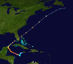
 Trasa huraganu | |
Huragan Wilma – potężny cyklon tropikalny, 21. sztorm i 12. huragan na Oceanie Atlantyckim w ciągu sześciu miesięcy 2005 roku. Jest również trzecim huraganem w tym sezonie, któremu przypisano najwyższą kategorię w pięciostopniowej skali Saffira-Simpsona. Naukowcy z amerykańskiego Narodowego Centrum Huraganów, uznali go za najsilniejsze zanotowane tego typu zjawisko w historii. Stwierdzono również, że dla tego huraganu, należałoby utworzyć kolejną – VI kategorię. Siła huraganu zmalała po przejściu nad meksykańskim stanem Jukatan 22 października 2005 roku, po którym stał się on huraganem 3 kategorii.
W drugim tygodniu października 2005 roku, rozległe i złożone obszary niskiego ciśnienia (depresja atmosferyczna) uformowały się nad zachodnią częścią Oceanu Atlantyckiego oraz wschodnimi wyspami Karaibskimi, którym towarzyszyło kilka centrów burz i sztormów. Ten obszar spowodował załamanie pogody w południowo-zachodniej części Jamajki. Zjawisko to powoli przeobrażało się w silny sztorm tropikalny, który 17 października 2005 roku nazwano Wilma. Sztorm przesuwając się powoli nad ciepłymi wodami Zatoki Meksykańskiej, rósł w siłę stając się huraganem 18 października 2005 roku. W ciągu 24 godzin wiatr urósł w siłę, przeobrażając się z silnego tropikalnego sztormu o prędkości 110 km/h w potężny huragan piątej kategorii z wiatrem przekraczającym 280 km/h. Wiatr zdecydowanie uspokoił się po przejściu nad Meksykiem, jego prędkość 23 października zmalała do 177 km/h.
Około godziny 16.00 czasu amerykańskiego (22.00 czasu polskiego), oko huraganu Wilma (strefa ciszy) które ma średnicę 65 km, znajdowało się nad meksykańskimi wyspami Cozumel (20°6′ N 86°9′ W), blisko stanu Quintana Roo. Przesuwając się na północny zachód z prędkością (9 km/h) 22 października uderzyła w meksykański półwysep Jukatan, gdzie pozbawiła domów i noclegów dziesiątki tysięcy ludzi, a śmierć poniosło 10 osób. W panice z egzotycznych wysp i wybrzeży meksykańskich uciekło ponad 35 tysięcy turystów. Huragan, który podczas 6 godzin w nocy z 21 na 22 października przesunął się tylko o niecałe 30 km, w zmienił kurs i skierował się na zachodnią Kubę, po czym ruszył na północ i uderzył w amerykański stan Floryda, gdzie gubernator Jeb Bush już kilka dni wcześniej ogłosił stan zagrożenia. W obawie przed huraganem władze Hondurasu zamknęły porty nad Zatoką Meksykańską. Stan zagrożenia ogłoszono na Kubie, w Nikaragui i Meksyku, a na wyspach Archipelagu Florida Keys zarządzono obowiązkową ewakuację mieszkańców. George W. Bush oraz gubernator Florydy Jeb Bush ogłosili na Florydzie stan klęski żywiołowej.
Wilma była najpotężniejszym zarejestrowanym huraganem wszech czasów 5 kategorii w skali Saffira-Simpsona, z wiatrem o sile prawie 295 km/h, centrum ciśnienia nieprzekraczającym 882 mbar (hPa) i frontem o rozpiętości 750 km.
Na wieść o przybraniu na sile przez huragan Wilma nerwowo zareagowały rynki paliwowe.
Ofiary
| Kraj | Ofiary śmiertelne |
|---|---|
| 13 | |
| 5 | |
| 4 | |
| 1 | |
| 1 | |
| Razem: | 24 |
Linki zewnętrzne
Media użyte na tej stronie
The national and official state flag of Haiti; arms obtained from http://www.webchantier.com/. The civil flag can be found at here.
The flag of Navassa Island is simply the United States flag. It does not have a "local" flag or "unofficial" flag; it is an uninhabited island. The version with a profile view was based on Flags of the World and as a fictional design has no status warranting a place on any Wiki. It was made up by a random person with no connection to the island, it has never flown on the island, and it has never received any sort of recognition or validation by any authority. The person quoted on that page has no authority to bestow a flag, "unofficial" or otherwise, on the island.
Flag of Jamaica. “The sunshine, the land is green, and the people are strong and bold” is the symbolism of the colours of the flag. GOLD represents the natural wealth and beauty of sunlight; GREEN represents hope and agricultural resources; BLACK represents the strength and creativity of the people. The original symbolism, however, was "Hardships there are, but the land is green, and the sun shineth", where BLACK represented the hardships being faced.
Track map of Hurricane Wilma of the 2005 Atlantic hurricane season. The points show the location of the storm at 6-hour intervals. The colour represents the storm's maximum sustained wind speeds as classified in the Saffir–Simpson scale (see below), and the shape of the data points represent the nature of the storm, according to the legend below.
Storm type
Hurricane Wilma remained a powerful Category 4 storm when the Moderate Resolution Imaging Spectroradiometer (MODIS) on NASA’s Terra satellite took this image at 12:25 p.m. Eastern Daylight Time, on Friday, October 21, 2005. Two days earlier, Wilma had surged from tropical storm to Category 5 hurricane in record time. Winds around the eyewall of the storm were raging at 280 kilometers per hour (175 miles per hour). National Oceanographic and Atmospheric Administration (NOAA) aircraft had also measured a record-low air pressure of 882 millibars in the center of Hurricane Wilma, making it the most intense hurricane ever observed in the Atlantic basin.
Since then, Wilma has lost some of her history-making strength, but this is little comfort to those in her path. In this image, the storm eye is about to cross Cozumel, a small island just off the Yucatan Peninsula coast. Winds were peaking at 230 km/hr (145 mph) as the eyewall passed over the island, and hurricane-strength winds extended for 130 kilometers (85 miles) from the storm’s center. As of Friday afternoon, Wilma was projected to continue into the Gulf of Mexico, bringing powerful winds and heavy rain to both western Cuba and the Yucatan Peninsula before turning toward southern Florida. Florida residents have already begun to prepare for the storm’s arrival.Hurricane Wilma was a powerful Category 5 storm when the Moderate Resolution Imaging Spectroradiometer (MODIS) on NASA’s Terra satellite took this image at 12:40 p.m. Eastern Daylight Time, on October 19, 2005. Less than 24 hours before this image was taken, Wilma had rapidly grown into a record-breaking, powerful storm. Winds around the eyewall of the storm were raging at 280 kilometers per hour (175 miles per hour). Just hours before, National Oceanographic and Atmospheric Administration (NOAA) aircraft measured a record-low air pressure of 882 millibars in the center of Hurricane Wilma, making it the most intense hurricane ever observed in the Atlantic basin. Wilma also broke records for the fastest development of a storm, going from tropical storm status to Category 5 hurricane in less than 24 hours.
The high-resolution image provided above has a spatial resolution of 250 meters per pixel. The MODIS Rapid Response Team provides this image at additional resolutions.Autor: Matrek (dyskusja · edycje), Licencja: CC BY-SA 3.0 us
Huragan Wilma w Key West


