Ilhas Desertas
| ||
 Zdjęcie lotnicze wysp | ||
| Kontynent | Afryka | |
| Państwo | ||
| Region autonomiczny | ||
| Akwen | Ocean Atlantycki | |
| Wyspy | 3 większe | |
| Powierzchnia | 14,21 km² | |
| Populacja • liczba ludności | 0 | |
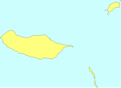
Mapa | ||
Ilhas Desertas (pol. Wyspy Pustynne) – niewielka grupa 3 niezamieszkanych wysp (pow. 14,21 km², maks. wysokość 488 m n.p.m.), położonych 25 km na południowy wschód od Madery. Należą do Portugalii, są skaliste i pustynne, od czego pochodzi ich nazwa. Wszystkich wysepek archipelagu Ilhas Desertas jest ponad 40.
W ich skład wchodzą
- Deserta Grande - pow. 10,0 km²; dł. 11,7 km; szer. 1,9 km; wysokość 488 m n.p.m.; 32°31′11″N 16°30′27″W/32,519722 -16,507500
- Bugio - pow. 3,0 km²; wysokość 411 m n.p.m.; 32°25′00″N 16°29′00″W/32,416667 -16,483333
- Chão - pow. 1,2 km²; wysokość 98 m n.p.m.; 33°35′00″N 16°32′00″W/33,583333 -16,533333
Media użyte na tej stronie
Flag of Portugal, created by Columbano Bordalo Pinheiro (1857-1929), officially adopted by Portuguese government in June 30th 1911 (in use since about November 1910). Color shades matching the RGB values officially reccomended here. (PMS values should be used for direct ink or textile; CMYK for 4-color offset printing on paper; this is an image for screen display, RGB should be used.)
Shiny LightSteelBlue button/marker widget. Used to mark the location of something such as a tourist attraction.
Autor: Jimfbleak, Licencja: CC BY-SA 3.0
view from the nature reserve base on Gran Deserta, Bugio Island is in the distance
Ilhas Desertas in Madeira archipelago, seen from airplane, june 2008.
Autor:
Flag of Autonomous Region of Madeira, Portugal
Blank SVG map of Madeira
Madeira: Its Climate and Scenery, map
Autor: Uwe Dedering, Licencja: CC BY-SA 3.0
Relief location map of Atlantic_Ocean.
- Projection: Lambert azimuthal equal-area projection.
- Area of interest:
- N: 70.0° N
- S: -70.0° N
- W: -95.0° E
- E: 25.0° E
- Projection center:
- NS: 0.0° N
- WE: -35.0° E
- GMT projection: -JA-35.0/0.0/180/19.998266666666666c
- GMT region: -R-147.58842045747764/-48.58942183011819/77.58842045747762/48.589421830118205r
- GMT region for grdcut: -R-148.0/-76.0/78.0/76.0r
- Relief: SRTM30plus.
- Made with Natural Earth. Free vector and raster map data @ naturalearthdata.com.


