Imperia
| miasto i gmina | |||
| |||
| Państwo | |||
|---|---|---|---|
| Region | |||
| Prowincja | |||
| Kod ISTAT | 008031 | ||
| Powierzchnia | 45 km² | ||
| Populacja (2004) • liczba ludności |
| ||
| • gęstość | 878,9 os./km² | ||
| Numer kierunkowy | 0183 | ||
| Kod pocztowy | 18100 | ||
| Strona internetowa | |||
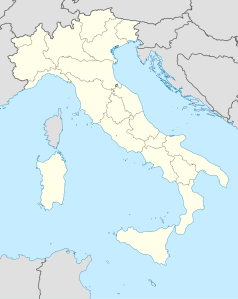
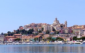
Imperia – miasto i gmina we Włoszech, w regionie Liguria, w prowincji Imperia. Położona jest nad Morzem Liguryjskim, u ujścia rzeki Impero.
Miasto powstało w 1923 roku z połączenia dwóch mniejszych miejscowości: Oneglii i Porto Maurizio.
Według danych na rok 2004 gminę zamieszkiwało 39 549 osób, gęstość zaludnienia wynosi 878,9 os./km².
W gminie znajdują się dwie stacje kolejowe: Imperia Oneglia oraz Imperia Porto Maurizio.
Miasta partnerskie
 Mandelieu-la-Napoule (Francja)
 Newport (Stany Zjednoczone)
 Rosario (Argentyna)
Linki zewnętrzne
- Źródło danych: Istituto Nazionale di Statistica
Media użyte na tej stronie
Autor:
- Map_of_region_of_Liguria,_Italy.svg: User:Vonvikken
- derivative work: Shadowxfox (talk)
Location map of Liguria region (Italy)
Autor: NordNordWest, Licencja: CC BY-SA 3.0
Location map of Italy (Commons photos) → en-Wikipedia Italy.
The flag of Navassa Island is simply the United States flag. It does not have a "local" flag or "unofficial" flag; it is an uninhabited island. The version with a profile view was based on Flags of the World and as a fictional design has no status warranting a place on any Wiki. It was made up by a random person with no connection to the island, it has never flown on the island, and it has never received any sort of recognition or validation by any authority. The person quoted on that page has no authority to bestow a flag, "unofficial" or otherwise, on the island.


