Independence (Missouri)
 | |
| Państwo | |
|---|---|
| Stan | |
| Data założenia | 1827[1] |
| Prawa miejskie | 1849[1] |
| Burmistrz | Rory Rowland↗ |
| Powierzchnia | 203,2 km² |
| Wysokość | 315 m n.p.m. |
| Populacja (2019) • liczba ludności • gęstość |
|
| Nr kierunkowy | 816 |
| Kod pocztowy | 64050–64057 |
| Strefa czasowa | |
| Strona internetowa | |
| Portal | |
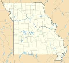
Independence – miasto w Stanach Zjednoczonych, w stanie Missouri, w zespole miejskim Kansas City, nad rzeką Verdigris. Siedziba hrabstwa Jackson. W 2019 roku liczy 116,7 tys. mieszkańców[2].
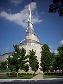
Independence to miejsce narodzin religijnego ruchu Świętych w Dniach Ostatnich[3], a także siedziba ogólnoświatowych władz i świątyni Kościoła Społeczności Chrystusa[4], co sprawia, że hrabstwo Jackson (28.159 członków i 4,2% populacji) jest największym skupiskiem mormonów w stanie Missouri[5].
Gospodarka
W mieście rozwinął się przemysł maszynowy, chemiczny, spożywczy oraz materiałów budowlanych[1].
Klimat
Miasto leży w strefie klimatu wilgotnego subtropikalnego, z gorącym latem, należącego według klasyfikacji Köppena do strefy Cfa. Średnia temperatura roczna wynosi 12,5 °C, a opady 1036,3 mm (w tym do 37 cm opadów śniegu)[6].
Historia
12 maja 1846 roku z miasta wyruszyła na zachód szlakiem kalifornijskim Wyprawa Donnera[7].
Zostało założone w 1869 roku przez firmę, która kupiła część Rezerwatu Indian Osage. Przeżywało okresowe ożywienie gospodarcze dzięki odkryciu gazu ziemnego w 1881 r. i pól naftowych w 1903 r.[4].
Urodzeni w Independence
- Ginger Rogers (1911–1995) – aktorka, tancerka i piosenkarka[8]
- Margaret Weis (ur. 1948) – powieściopisarka
- Jim Butcher (ur. 1971) – powieściopisarz
- Bess Truman (1885–1982) – pierwsza dama Stanów Zjednoczonych
Przypisy
- ↑ a b c Independence, [w:] Encyklopedia PWN [online] [dostęp 2021-07-11].
- ↑ US Census Bureau, Population and Housing Unit Estimates Tables, The United States Census Bureau [dostęp 2021-05-29] (ang.).
- ↑ Independence Visitors' Center in Missouri, Historic Sites, history.churchofjesuschrist.org [dostęp 2021-05-29].
- ↑ a b Community of Christ, [w:] Encyclopædia Britannica [online] [dostęp 2021-05-29] (ang.).
- ↑ Latter-day Saints Counties (2010) - QuickLists, www.thearda.com [dostęp 2021-05-29].
- ↑ Climate Summary, Hillsboro, Ohio. Weatherbase. [dostęp 2017-06-21]. (ang.).
- ↑ Donner party, [w:] Encyclopædia Britannica [online] [dostęp 2022-09-30] (ang.).
- ↑ Famous People From Independence, Missouri - #1 is Ginger Rogers, Playback.fm [dostęp 2021-05-29] (ang.).
Media użyte na tej stronie
Autor: Uwe Dedering, Licencja: CC BY-SA 3.0
Location map of the USA (without Hawaii and Alaska).
EquiDistantConicProjection:
Central parallel:
* N: 37.0° N
Central meridian:
* E: 96.0° W
Standard parallels:
* 1: 32.0° N
* 2: 42.0° N
Made with Natural Earth. Free vector and raster map data @ naturalearthdata.com.
Formulas for x and y:
x = 50.0 + 124.03149777329222 * ((1.9694462586094064-({{{2}}}* pi / 180))
      * sin(0.6010514667026994 * ({{{3}}} + 96) * pi / 180))
y = 50.0 + 1.6155950752393982 * 124.03149777329222 * 0.02613325650382181
      - 1.6155950752393982  * 124.03149777329222 *
     (1.3236744353715044  - (1.9694462586094064-({{{2}}}* pi / 180))
      * cos(0.6010514667026994 * ({{{3}}} + 96) * pi / 180))
The flag of Navassa Island is simply the United States flag. It does not have a "local" flag or "unofficial" flag; it is an uninhabited island. The version with a profile view was based on Flags of the World and as a fictional design has no status warranting a place on any Wiki. It was made up by a random person with no connection to the island, it has never flown on the island, and it has never received any sort of recognition or validation by any authority. The person quoted on that page has no authority to bestow a flag, "unofficial" or otherwise, on the island.
Community of Christ Temple in Independence, Missouri
Autor: TheCatalyst31 with modifications by Kbh3rd, Licencja: CC BY-SA 3.0
Jackson County Courthouse in Independence, Missouri, listed on the National Register of Historic Places.
Autor: Alexrk2, Licencja: CC BY 3.0
Ta mapa została stworzona za pomocą GeoTools.


