Indre (departament)
| Departament | |||||
 | |||||
| Państwo | |||||
|---|---|---|---|---|---|
| Region | |||||
| Prefektura | Châteauroux | ||||
| Kod ISO 3166-2 | FR-36 | ||||
| Powierzchnia | 6903 km² | ||||
| Populacja (2012[1]) • liczba ludności |
| ||||
| • gęstość | 33 os./km² | ||||
| Szczegółowy podział administracyjny | |||||
| Liczba podprefektur | 3 | ||||
| Liczba kantonów | 26 | ||||
| Liczba gmin | 247 | ||||
Położenie na mapie | |||||
| Portal | |||||
Indre [ɛ̃ːdʀ] – francuski departament położony w Regionie Centralnym. Departament oznaczony jest liczbą 36. Departament został utworzony 4 marca 1790 roku. Jego nazwa pochodzi od rzeki Indre.
Według danych na rok 2012 liczba zamieszkującej departament ludności wynosi 231 176 os. (33 os./km²); powierzchnia departamentu to 6791 km². Prefekturą departamentu Indre jest miasto Châteauroux.
Prezydentem departamentu jest Louis Pinton.
Liczba gmin w departamencie: 247
Zobacz też
- podział administracyjny Francji
- regiony i departamenty Francji
- Gminy departamentu Indre
Przypisy
- ↑ INSEE: Populations légales 2010 pour les départements et les collectivités d'outre-mer (fr.). [dostęp 2013-09-07].
Media użyte na tej stronie
Autor: Original map : Sting, modifications by Floppy36, Licencja: CC BY-SA 3.0
Carte administrative représentant le département de l'Indre sur une carte de France métropolitaine.
Autor: Benjism89, Licencja: CC BY-SA 3.0
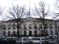
The préfecture (Government's local representative's building) of Châteauroux, Indre, France.
Blason du département de l'Indre :
d'azur à trois jumelles ondées d'argent, accompagnées en chef d'un château d'argent ouvert de sable, couvert et pavillonné de gueules, accosté de deux fleurs de lys d'or en chef et accompagnées en pointe d'une fleur de lys aussi d'or, à la bordure engrêlée de gueules.


