Iowa (rzeka)
 Dorzecze rzeki Iowa | |
| Kontynent | Ameryka Północna |
|---|---|
| Państwo | |
| Rzeka | |
| Długość | 520 km |
| Źródło | |
| Współrzędne | 43°13′33,5″N 93°47′19,4″W/43,225970 -93,788710 |
| Ujście | |
| Recypient | Missisipi |
| Współrzędne | 41°09′42,4″N 91°01′21,5″W/41,161776 -91,022640 |
Położenie na mapie Stanów Zjednoczonych  | |
Iowa (ang. Iowa River) – rzeka w amerykańskim stanie Iowa, dopływ rzeki Missisipi. Jej długość wynosi 520 km.
Galeria

Iowa River w pobliżu Marshalltown

Rzeka Iowa zimą, widziana z kampusu University of Iowa
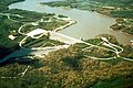
Zapora Coralville (Coralville Dam) i zbiornik na rzece Iowa w pobliżu Coralville, Iowa
Zobacz też
Bibliografia
(ang.) [dostęp 6 kwietnia 2014]
Media użyte na tej stronie
Usa edcp relief location map.png
Autor: Uwe Dedering, Licencja: CC BY-SA 3.0
Relief location map of the USA (without Hawaii and Alaska).
Autor: Uwe Dedering, Licencja: CC BY-SA 3.0
Relief location map of the USA (without Hawaii and Alaska).
EquiDistantConicProjection : Central parallel :
* N: 37.0° N
Central meridian :
* E: 96.0° W
Standard parallels:
* 1: 32.0° N
* 2: 42.0° N
Made with Natural Earth. Free vector and raster map data @ naturalearthdata.com.
Formulas for x and y:
x = 50.0 + 124.03149777329222 * ((1.9694462586094064-({{{2}}}* pi / 180))
      * sin(0.6010514667026994 * ({{{3}}} + 96) * pi / 180))
y = 50.0 + 1.6155950752393982 * 124.03149777329222 * 0.02613325650382181
      - 1.6155950752393982  * 124.03149777329222 *
     (1.3236744353715044  - (1.9694462586094064-({{{2}}}* pi / 180))
      * cos(0.6010514667026994 * ({{{3}}} + 96) * pi / 180))

Flag of the United States.svg
The flag of Navassa Island is simply the United States flag. It does not have a "local" flag or "unofficial" flag; it is an uninhabited island. The version with a profile view was based on Flags of the World and as a fictional design has no status warranting a place on any Wiki. It was made up by a random person with no connection to the island, it has never flown on the island, and it has never received any sort of recognition or validation by any authority. The person quoted on that page has no authority to bestow a flag, "unofficial" or otherwise, on the island.
The flag of Navassa Island is simply the United States flag. It does not have a "local" flag or "unofficial" flag; it is an uninhabited island. The version with a profile view was based on Flags of the World and as a fictional design has no status warranting a place on any Wiki. It was made up by a random person with no connection to the island, it has never flown on the island, and it has never received any sort of recognition or validation by any authority. The person quoted on that page has no authority to bestow a flag, "unofficial" or otherwise, on the island.


USACE Coralville Reservoir Iowa.jpg
Coralville Reservoir and dam on the Iowa River near Coralville, Iowa, USA.
Coralville Reservoir and dam on the Iowa River near Coralville, Iowa, USA.
Iowarivermap.png
Autor: Kmusser, Licencja: CC BY-SA 2.5
Map of the Iowa River watershed, including its longest tributary, the Cedar River — in Iowa.
Autor: Kmusser, Licencja: CC BY-SA 2.5
Map of the Iowa River watershed, including its longest tributary, the Cedar River — in Iowa.
