Irapuato
| |||||
 | |||||
| Państwo | |||||
| Stan | |||||
| Zarządzający | Mario Turrent Antón | ||||
| Powierzchnia | 845,16 km² | ||||
| Wysokość | 1730 m n.p.m. | ||||
| Populacja (2005) • liczba ludności | 463 103[1] | ||||
| Nr kierunkowy | 462 | ||||
| Kod pocztowy | 36500 – 36899 | ||||
| Strona internetowa | |||||
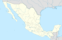
Irapuato – miasto w środkowym Meksyku, w stanie Guanajuato, na obszarze Mesy Centralnej, na wysokości 1800 metrów. Około 440,1 tys. mieszkańców.
Historia
W okresie pre-hiszpańskim rejon zamieszkiwali Indianie z koczowniczego szczepu Czichimeków. Później teren został podbity przez Indian Tarascan, którzy tworząc stałą siedzibę nadali miastu nazwę oznaczającą miejsce bagienne. Obecna nazwa pochodzi o tego słowa i jest używana od założenia miasta przez kolonizatorów hiszpańskich w 1547 roku. Prawa miejskie nadano w 1893.
Gospodarka
Irapuato jest ważnym ośrodkiem rolniczym z ogromnymi plantacjami truskawek. Rozwinął się tu również przemysł, szczególnie chemiczny, młynarski i skórzano-obuwniczy. W okolicach Irapuato wydobywa się srebro i złoto.
Miasta partnerskie
 Green Bay, USA
 McAllen, USA
 Murcja, Hiszpania
 Houston, Stany Zjednoczone
 Laredo, Stany Zjednoczone
 Marianao, Kuba
Bibliografia
Przypisy
- ↑ Instituto Nacional de Estadística, Geografía e Informática. Principales resultados por localidad 2005 (ITER) (hiszp.). [dostęp 2010-12-29].
Media użyte na tej stronie
The flag of Navassa Island is simply the United States flag. It does not have a "local" flag or "unofficial" flag; it is an uninhabited island. The version with a profile view was based on Flags of the World and as a fictional design has no status warranting a place on any Wiki. It was made up by a random person with no connection to the island, it has never flown on the island, and it has never received any sort of recognition or validation by any authority. The person quoted on that page has no authority to bestow a flag, "unofficial" or otherwise, on the island.
Autor: Pedro A. Gracia Fajardo, escudo de Manual de Imagen Institucional de la Administración General del Estado, Licencja: CC0
Flaga Hiszpanii
Autor: Alberium, Licencja: CC BY-SA 3.0
Bandera de la ciudad de Irapuato, Guanajuato, México.
Historic Downtown of Irapuato (In this picture you can see the Templo del Hospitalito, and the Arandas mountain in the background) The picture was taken from one of the balconies of the city's Presidencia (Historic City Hall)
Autor: unknown, Licencja: Attribution
Autor: Battroid, Licencja: CC BY-SA 3.0
Mapa de los municipios del estado de Guanajuato, México


