Irbil (muhafaza)
| prowincja | |
 | |
| Państwo | |
|---|---|
| Siedziba | |
| Kod ISO 3166-2 | IQ-AR |
| Powierzchnia | 12 000 km² |
| Populacja (2015) • liczba ludności |
|
| • gęstość | 150 os./km² |
Położenie na mapie Iraku | |
Irbil (arab. أربيل, kurd. Hewlêr) – jedna z 18 prowincji Iraku. Znajduje się w północnej części kraju, stanowi część Kurdyjskiego Okręgu Autonomicznego. Stolicą prowincji, jak i również całego Okręgu Autonomicznego, jest miasto Irbil.
Miasta prowincji
- Chalifan, Kuj Sandżak
Media użyte na tej stronie
Coat of arms of Iraq as adapted to new 2008 form of national flag -- standard pan-Arab "Eagle of Saladin" with shield of the tricolor of national flag (with the "Takbir" الله أكبر in Kufic text, as on the flag), holding a scroll with the words جمهورية العراق; (Jumhuriyat al-`Iraq "The Republic of Iraq").
Autor: PANONIAN, Licencja: CC0
Map showing the governorates of Kurdistan Region in Iraq (in 2012).
Autor: PANONIAN, Licencja: CC0
Map showing the districts of the Hewlêr (Erbil) Governorate of Kurdistan Region in Iraq (in 2012).
Autor: TUBS
Location of province XY (see filename) in Iraq
Autor: Jim Gordon, Hwnar M. S., Ara Qadir, Siyar Taha Khalid, Licencja: CC BY-SA 3.0
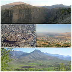
Clockwise, from top: Canyon in Rawanduz, Koy Sanjaq, Shaqlawa and Citadel of Erbil
Coat of arms of Iraq as adapted to new 2008 form of national flag -- standard pan-Arab "Eagle of Saladin" with shield of the tricolor of national flag (with the "Takbir" الله أكبر in Kufic text, as on the flag), holding a scroll with the words جمهورية العراق; (Jumhuriyat al-`Iraq "The Republic of Iraq").


