Irlandia (wyspa)
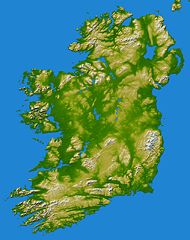
 Zdjęcie satelitarne wyspy | |
| Kontynent | |
|---|---|
| Państwo | |
| Akwen | |
| Powierzchnia | 84 406 km² |
| Populacja (2008) • liczba ludności • gęstość |
|
 | |
Irlandia – trzecia pod względem wielkości wyspa w Europie. Pod względem politycznym wyspa podzielona jest na dwie części: Irlandię i Irlandię Północną, która jest częścią Zjednoczonego Królestwa Wielkiej Brytanii i Irlandii Północnej.
Geografia
Położenie
Irlandia należy do archipelagu Wysp Brytyjskich, jest trzecią co do wielkości wyspą Europy. Jej powierzchnia wynosi 84 406 km², większa od niej jest Islandia oraz Wielka Brytania. Od północy i zachodu oblewają ją wody Oceanu Atlantyckiego, natomiast na wschodzie i południowym wschodzie oddziela ją od Wielkiej Brytanii Morze Irlandzkie, Kanał Świętego Jerzego i Kanał Północny. Linia brzegowa jest bardzo urozmaicona, jej długość wynosi 1448 km[1].
- Położenie geograficzne Irlandii określają współrzędne:
- szerokość geograficzna 51°30'-55°30'N
- długość geograficzna 6°00'-10°30'W
Klimat
Klimat Irlandii określa się jako typ klimatu umiarkowanego morskiego wilgotnego. Na jego kształtowanie największy wpływ mają napływające z południowego zachodu masy powietrza znad Oceanu Atlantyckiego i łagodząca działalność Prądu Północnoatlantyckiego. Średnie temperatury powietrza wahają się między 4 a 7 °C w styczniu i lutym, 14 do 16 °C w lipcu i sierpniu. Najwyższą temperaturę 33,3 °C zanotowano na zamku Kilkenny w hrabstwie Kilkenny 26 czerwca 1887 roku. Najniższą zaś wynoszącą -19,1 °C na zamku Markree w hrabstwie Sligo 16 stycznia 1881 roku. Ilość opadów jest różna: od 760 mm na wschodzie do 2540 mm na zachodnim wybrzeżu. Największe dzienne nasłonecznienie jest w maju i czerwcu i wynosi wtedy 5,5 do 6,5 godziny/dobę.
Fauna i flora
Irlandia należy do atlantyckiej strefy roślinnej, a jej naturalną formacją roślinną jest las liściasty dębowy. Fakt, iż podczas zlodowacenia cała Irlandia była pokryta lądolodem, spowodował występowanie charakterystycznych odmian roślin. Istnieje tu niecodzienna kombinacja gatunków arktycznych, alpejskich a nawet wiele gatunków roślin wiecznie zielonych charakterystycznych dla basenu Morza Śródziemnego czy Ameryki Północnej. Oddzielenie się wyspy w okresie topnienia lądolodu wpłynęło także na faunę tego obszaru. Obecnie na Irlandii występuje 35 gatunków lądowych ssaków, wśród nich: sarny, zające, króliki, lisy, wiewiórki, borsuki, a także endemiczne podgatunki: zająca – Lepus timidus hibernicus i gronostaja – Mustela erminea hibernica (spotykany także na wyspie Man). W przeciwieństwie do stosunkowo małej liczby ssaków lądowych zamieszkujących wyspę, ssaki morskie są licznie reprezentowane przez: foki, delfiny, morświny i wieloryby. Olbrzymie jest tu także bogactwo ptaków, część z nich migruje tutaj z Grenlandii czy Islandii. Zaobserwowano przedstawicieli 380 gatunków. W rzekach i strumieniach wyspy występuje wiele gatunków ryb – najliczniejsze są: łososiowate, w tym pstrągi, szczupakowate, węgorzowate. W celu ochrony środowiska przyrodniczego w Irlandii powołano sześć parków narodowych. W Irlandii Północnej do tej pory nie powstał żaden park narodowy, natomiast istnieje kilka rezerwatów przyrody.
Interesujące miejsca
Zobacz też
Przypisy
- ↑ The World Factbook. Coastline. [dostęp 2014-07-19]. [zarchiwizowane z tego adresu (2017-07-16)].
Media użyte na tej stronie
Autor: Alexrk2, Licencja: CC BY-SA 3.0
Physical location map Europe; Lambert azimuthal equal-area projection
Autor: Lutz Fischer-Lamprecht, Licencja: CC BY-SA 4.0
Ladies view in County Kerry
Elevation data in this topographical image of Ireland were acquired by the Shuttle Radar Topography Mission on board the STS-99 flight of the Space Shuttle Endeavour, launched on 11 February 2000.
The island of Ireland comprises a large central lowland of limestone with a relief of hills surrounded by a discontinuous border of coastal mountains which vary greatly in geological structure. The mountain ridges of the south are composed of old red sandstone separated by limestone river valleys. Granite predominates in the mountains of Counties Galway, Mayo, and Donegal in the west and north-west and in Counties Down and Wicklow on the east coast, while a basalt plateau covers much of the north-east of the country. The central plain, which is broken in places by low hills, is extensively covered with glacial deposits of clay and sand. It has considerable areas of bog and numerous lakes. The island has seen at least two general glaciations and everywhere ice-smoothed rock, mountain lakes, glacial valleys and deposits of glacial sand, gravel and clay mark the passage of the ice.
Two visualisation methods were combined to produce this image: shading and colour coding of topographic height. The shade image was derived by computing topographic slope in the northwest-southeast direction, so that northwest slopes appear bright and southeast slopes appear dark. Colour coding is directly related to topographic height, with green at the lower elevations, rising through yellow and tan, to white at the highest elevations.
Elevation data used in this image were acquired by the Shuttle Radar Topography Mission on board the Space Shuttle Endeavour, launched on 11 February 2000. SRTM used the same radar instrument that comprised the Spaceborne Imaging Radar-C/X-Band Synthetic Aperture Radar (SIR-C/X-SAR) that flew twice on the Space Shuttle Endeavour in 1994. SRTM was designed to collect 3-D measurements of the Earth's surface. To collect the 3-D data, engineers added a 60-metre (approximately 200-foot) mast, installed additional C-band and X-band antennas, and improved tracking and navigation devices. The mission was a cooperative project between NASA, the National Geospatial-Intelligence Agency (NGA) of the U.S. Department of Defense and the German and Italian space agencies. It was managed by NASA's Jet Propulsion Laboratory, Pasadena, California, for NASA's Earth Science Enterprise, Washington, D.C.
Location: 53.5 degrees North latitude, 8 degrees West longitude
Orientation: North toward the top, Mercator projection
It is easy to see from this true-colour image why Ireland is called the Emerald Isle. Intense green vegetation, primarily grassland, covers most of the country except for the exposed rock on mountaintops. Ireland owes its greenness to moderate temperatures and moist air. The Atlantic Ocean, particularly the warm currents in the North Atlantic Drift, gives the country a more temperate climate than most others at the same latitude.


