Itoshima
| |||||||
 | |||||||
| Państwo | |||||||
|---|---|---|---|---|---|---|---|
| Prefektura | |||||||
| Wyspa | |||||||
| Region | |||||||
| Burmistrz | Yūji Tsukigata (od 14.02.2014) | ||||||
| Powierzchnia | 215,70 km² | ||||||
| Populacja (2015.10.01) • liczba ludności • gęstość |
| ||||||
| Kod pocztowy | 819-1192 | ||||||
| Symbole japońskie | |||||||
| Drzewo | |||||||
| Kwiat | Hibiscus hamabo | ||||||
| Strona internetowa | |||||||
| Portal | |||||||
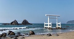
Itoshima (jap. 糸島市 Itoshima-shi) – miasto w Japonii, w prefekturze Fukuoka, na wyspie Kiusiu.
Historia
Miasto Itoshima powstało 1 stycznia 2010 roku w wyniku połączenia miasta Maebaru oraz miasteczek Shima i Nijō (z powiatu Itoshima)[1].
Populacja
Zmiany w populacji Itoshimy w latach 1970–2015:
| Rok | Populacja |
|---|---|
| 1970 | 56 204 |
| 1975 | 59 697 |
| 1980 | 66 220 |
| 1985 | 73 649 |
| 1990 | 77 610 |
| 1995 | 88 691 |
| 2000 | 95 040 |
| 2005 | 97 974 |
| 2010 | 98 435 |
| 2015 | 96 475 |
Przypisy
Linki zewnętrzne
- Oficjalna strona miasta (jap.)
Media użyte na tej stronie
Autor: Created by LERK, Licencja: Copyrighted free use
The shadow picture of Fukuoka Prefecture, Japan
Autor: Maximilian Dörrbecker (Chumwa), Licencja: CC BY-SA 3.0
Location map of Japan
Equirectangular projection.
Geographic limits to locate objects in the main map with the main islands:
- N: 45°51'37" N (45.86°N)
- S: 30°01'13" N (30.02°N)
- W: 128°14'24" E (128.24°E)
- E: 149°16'13" E (149.27°E)
Geographic limits to locate objects in the side map with the Ryukyu Islands:
- N: 39°32'25" N (39.54°N)
- S: 23°42'36" N (23.71°N)
- W: 110°25'49" E (110.43°E)
- E: 131°26'25" E (131.44°E)
Flag of Fukuoka prefecture, Japan
Flag of Itoshima Fukuoka
福岡県糸島市章
Autor: STA3816, Licencja: CC BY-SA 3.0
Sakurai Futamigaura, Itoshima, Fukuoka, Japan
Autor: Lincun, Licencja: CC BY-SA 3.0
Map of Fukuoka Prefecture, Japan.


