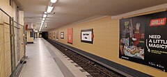
Jakob-Kaiser-Platz (stacja metra)
| Ten artykuł od 2020-12 wymaga zweryfikowania podanych informacji. |
 | |
| Państwo | |
|---|---|
| Kraj związkowy | |
| Data otwarcia | 1 października 1980 |
| U7 | |
| Poprzednia stacja | |
| Następna stacja | |
Położenie na mapie Berlina (c) TUBS, CC BY-SA 3.0 | |
| Portal | |
Jakob-Kaiser-Platz – stacja metra w Berlinie na linii U7, w dzielnicy Charlottenburg-Nord, w okręgu administracyjnym Charlottenburg-Wilmersdorf. Stacja została otwarta w 1980.
Media użyte na tej stronie
Autor: NordNordWest, Licencja: CC BY-SA 3.0
Location map of Germany (Wp article: en:Germany)
Autor: Dasas, Licencja: CC BY-SA 4.0
The platform at the Jakob-Kaiser-Platz U-Bahn station on Berlin's U7 underground line received a new design on the rear track walls and on the platform itself. The picture shows the station during construction in January 2022.
(c) TUBS, CC BY-SA 3.0
Location map Berlin, Germany. Geographic limits of the map:


