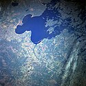
Jezioro Leśne (Kanada i USA)
 | |
| Położenie | |
| Państwo | |
|---|---|
| Miejscowości nadbrzeżne | Kenora |
| Wysokość lustra | 323 m n.p.m. |
| Morfometria | |
| Powierzchnia | 4350 km² |
| Wymiary • max długość • max szerokość |
|
| Głębokość • maksymalna |
|
| Hydrologia | |
| Rzeki zasilające | Rainy River |
| Rzeki wypływające | |
| Rodzaj jeziora | |
Jezioro Leśne (ang. Lake of the Woods, fr. Lac des Bois) – jezioro pochodzenia polodowcowego na granicy Kanady (prowincji Ontario) i Stanów Zjednoczonych (stanu Minnesota). Zajmuje powierzchnię około 4350 km²[1][2].
Zasilane jest w wodę przez Rainy River, Shoal Lake, Kakagi Lake. Posiada odpływ poprzez rzekę Winnipeg do jeziora Winnipeg. Na jeziorze znajduje się około 14,5 tys. wysp[2][3], z których największe to: Big Island, Bigsby Island, Oak Island, Flag Island, Penasse Island, Magnuson's Island. Półwysep Aulneau został przekształcony w sztuczną wyspę.
Jezioro Leśne stanowi pozostałość istniejącego w plejstocenie jeziora Agassiz.
Przypisy
Media użyte na tej stronie
Flag of Canada introduced in 1965, using Pantone colors. This design replaced the Canadian Red Ensign design.
The flag of Navassa Island is simply the United States flag. It does not have a "local" flag or "unofficial" flag; it is an uninhabited island. The version with a profile view was based on Flags of the World and as a fictional design has no status warranting a place on any Wiki. It was made up by a random person with no connection to the island, it has never flown on the island, and it has never received any sort of recognition or validation by any authority. The person quoted on that page has no authority to bestow a flag, "unofficial" or otherwise, on the island.
Autor: Tzugaj, Licencja: CC0
znak graficzny do map, ukazujący przykładowe jezioro
Autor: Uwe Dedering, Licencja: CC BY-SA 3.0
Relief location map of North America.
- Projection: Lambert azimuthal equal-area projection.
- Area of interest:
- N: 90.0° N
- S: 5.0° N
- W: -140.0° E
- E: -60.0° E
- Projection center:
- NS: 47.5° N
- WE: -100.0° E
- GMT projection: -JA-100/47.5/20.0c
- GMT region: -R-138.3726888474925/-3.941007863604182/2.441656573833029/50.63933645705661r
- GMT region for grdcut: -R-220.0/-4.0/20.0/90.0r
- Relief: SRTM30plus.
- Made with Natural Earth. Free vector and raster map data @ naturalearthdata.com.


