Joué-lès-Tours
| miejscowość i gmina | |||
 | |||
| |||
| Państwo | |||
|---|---|---|---|
| Region | |||
| Departament | |||
| Okręg | |||
| Kod INSEE | 37122 | ||
| Powierzchnia | 32,42 km² | ||
| Populacja (1990) • liczba ludności |
| ||
| • gęstość | 1135 os./km² | ||
| Kod pocztowy | 37300 | ||
| Portal | |||
Joué-lès-Tours – miejscowość i gmina we Francji, w Regionie Centralnym, w departamencie Indre i Loara.
Według danych na rok 1990 gminę zamieszkiwało 36 798 osób, a gęstość zaludnienia wynosiła 1135 osób/km² (wśród 1842 gmin Regionu Centralnego Joué-lès-Tours plasuje się na 7. miejscu pod względem liczby ludności, natomiast pod względem powierzchni na miejscu 299.).
Miasta partnerskie
 Hechingen, Niemcy
 East Ayrshire, Szkocja
 Santa Maria da Feira, Portugalia
 Città di Castello, Włochy
 Ogre, Łotwa
Bibliografia
- Francuski urząd statystyczny. (fr.).
Media użyte na tej stronie
Autor: Flappiefh, Licencja: CC BY-SA 4.0
Blank administrative map of the department of Indre-et-Loire, France, for geo-location purpose.
Autor: Superbenjamin, Licencja: CC BY-SA 4.0
Blank administrative map of France for geo-location purpose, with regions and departements distinguished. Approximate scale : 1:3,000,000
Autor: Flappiefh, Licencja: CC BY-SA 4.0
Carte administrative vierge de la région Centre-Val de Loire, France, destinée à la géolocalisation.
Flag of Portugal, created by Columbano Bordalo Pinheiro (1857-1929), officially adopted by Portuguese government in June 30th 1911 (in use since about November 1910). Color shades matching the RGB values officially reccomended here. (PMS values should be used for direct ink or textile; CMYK for 4-color offset printing on paper; this is an image for screen display, RGB should be used.)
Autor: Angela Monika Arnold, Licencja: CC BY-SA 2.0 de
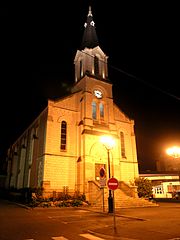
Kirche in Joué-lès-Tours


