Joué-sur-Erdre
| miejscowość i gmina | |||
 Kościół | |||
| |||
| Państwo | |||
|---|---|---|---|
| Region | |||
| Departament | |||
| Okręg | |||
| Kod INSEE | 44077 | ||
| Powierzchnia | 54,38 km² | ||
| Populacja (2010[1]) • liczba ludności |
| ||
| • gęstość | 39 os./km² | ||
| Kod pocztowy | 44440 | ||
Położenie na mapie Loary Atlantyckiej  | |||
Położenie na mapie Francji  | |||
Położenie na mapie Kraju Loary  (c) Eric Gaba, Wikimedia Commons user Sting, CC BY-SA 3.0 | |||
| Portal | |||
.svg)
Joué-sur-Erdre – miejscowość i gmina we Francji, w regionie Kraj Loary, w departamencie Loara Atlantycka.
Według danych na rok 2010 gminę zamieszkiwało 2163 osoby, a gęstość zaludnienia wynosiła 39 osób/km².

Joué-sur-Erdre.

La Demenure.

La Mulonnière.
La Gicquelière.
Przypisy
- ↑ INSEE: Populations légales 2010 - 44-Loire-Atlantique (fr.). [dostęp 2013-09-16].
Media użyte na tej stronie
Loire-Atlantique department location map.svg
Autor: Eric Gaba (Sting - fr:Sting), Licencja: CC BY-SA 3.0
Blank administrative map of the department of Loire-Atlantique, France, for geo-location purpose, with distinct boundaries for regions, departments and arrondissements as in January 2018.
Autor: Eric Gaba (Sting - fr:Sting), Licencja: CC BY-SA 3.0
Blank administrative map of the department of Loire-Atlantique, France, for geo-location purpose, with distinct boundaries for regions, departments and arrondissements as in January 2018.
France location map-Regions and departements-2016.svg
Autor: Superbenjamin, Licencja: CC BY-SA 4.0
Blank administrative map of France for geo-location purpose, with regions and departements distinguished. Approximate scale : 1:3,000,000
Autor: Superbenjamin, Licencja: CC BY-SA 4.0
Blank administrative map of France for geo-location purpose, with regions and departements distinguished. Approximate scale : 1:3,000,000
Pays de la Loire region location map.svg
(c) Eric Gaba, Wikimedia Commons user Sting, CC BY-SA 3.0
Blank administrative map of the region of Pays de la Loire, France, as in February 2011, for geo-location purpose, with distinct boundaries for regions, departments and arrondissements.
(c) Eric Gaba, Wikimedia Commons user Sting, CC BY-SA 3.0
Blank administrative map of the region of Pays de la Loire, France, as in February 2011, for geo-location purpose, with distinct boundaries for regions, departments and arrondissements.
.svg)
.svg)
Carte de La Demenure (Joué-sur-Erdre).svg
Autor: Treehill, Licencja: CC BY 3.0
Carte du lieu-dit de La Demenure à Joué-sur-Erdre. Les indications topographiques ne sont qu'approximatives.
Autor: Treehill, Licencja: CC BY 3.0
Carte du lieu-dit de La Demenure à Joué-sur-Erdre. Les indications topographiques ne sont qu'approximatives.

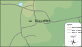
Bourg de Joué-sur-Erdre.svg
Autor: Treehill, Licencja: CC BY 3.0
Carte du bourg de Joué-sur-Erdre. La topographie n'est que très approximative et ne sert qu'à illustrer simplement le fond de carte
Autor: Treehill, Licencja: CC BY 3.0
Carte du bourg de Joué-sur-Erdre. La topographie n'est que très approximative et ne sert qu'à illustrer simplement le fond de carte
.svg)
Carte de la Mulonnière (Joué-sur-Erdre).svg
Autor: Treehill, Licencja: CC BY 3.0
Carte du lieu dit de la Demenure à Joué-sur-Erdre. Les données topos ne sont qu'approximatives et ne sont là que pour donner une idée du terrain.
Autor: Treehill, Licencja: CC BY 3.0
Carte du lieu dit de la Demenure à Joué-sur-Erdre. Les données topos ne sont qu'approximatives et ne sont là que pour donner une idée du terrain.
Église St Léger de Joué-sur-Erdre-edit.JPG
Autor: Treehill, Licencja: CC BY-SA 3.0
église St Léger de Joué-sur-Erdre
Autor: Treehill, Licencja: CC BY-SA 3.0
église St Léger de Joué-sur-Erdre
.svg)
La Gicquelière (Joué-sur-Erdre).svg
Autor: Treehill, Licencja: CC BY 3.0
Carte du lieu-dit de la Gicquelière à Joué-sur-Erdre. La topographie n'est que très approximative.
Autor: Treehill, Licencja: CC BY 3.0
Carte du lieu-dit de la Gicquelière à Joué-sur-Erdre. La topographie n'est que très approximative.