Königssee
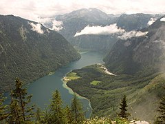
 Königssee, widok z góry Archenkanzel | |
| Położenie | |
| Państwo | |
|---|---|
| Kraj związkowy | |
| Miejscowości nadbrzeżne | Schönau am Königssee |
| Region | |
| Wysokość lustra | 603,30 m n.p.m. |
| Morfometria | |
| Powierzchnia | 5,218 km² |
| Głębokość • maksymalna |
|
| Długość linii brzegowej | 19,96 km |
Königssee (pol. Jezioro królewskie) to jezioro w Bawarii. Leży na południowy wschód od Monachium. Przez jezioro Königssee przepływa rzeka Königsseer Ache.
Galeria
Zobacz też
Media użyte na tej stronie
Autor: Tzugaj, Licencja: CC0
znak graficzny do map, ukazujący przykładowe jezioro
Autor: Bobak Ha'Eri, Licencja: CC BY 3.0
Königssee, Germany. Taken just after dawn, before the first boats (and resulting ripples that ruin the mirror-effect). St. Batholomä Church can be seen on the far edge of the lake.
Autor: derivative work Виктор_В, Licencja: CC BY-SA 3.0
Relief map of Germany
Autor: BerndH, Licencja: CC-BY-SA-3.0
Southern half of Lake Königsse as seen from Archenkanzel vista point, shortly after a thunderstorm. The small flat area in the center of the picture represents the vegetated alluvial fan of the Eisbach creek with the St-Bartholomew’s chapel.
Autor: Bobak Ha'Eri, Licencja: CC BY 3.0
Königssee, Germany, from the harbor of Schönau am Königssee. Taken just before dusk, after all the boats (and their ripples that ruin the mirror-effect) have finished for the day.
Autor: Gerd Eichmann, Licencja: CC BY-SA 4.0
Königssee in the Berchtesgaden Alps
Autor: Grundkarte TUBS, Relief Alexrk2, Licencja: CC BY-SA 3.0
Physical Location map Bavaria, Germany. Geographic limits of the map:


