KVLY/KTHI TV Mast
 | |
| Państwo | |
|---|---|
| Stan | |
| Miejscowość | |
| Wysokość całkowita | 628,8 m |
| Ukończenie budowy | |
| Właściciel | Hoak Media |
Położenie na mapie Dakoty Północnej  | |
Położenie na mapie Stanów Zjednoczonych  | |
KVLY/KTHI TV Mast – obecnie najwyższy maszt telewizyjny świata mierzący 628,8 metra. Znajduje się 4,8 km na zachód od miejscowości Blanchard w Północnej Dakocie. Do użytku został oddany 13 sierpnia 1963 roku.
Był najwyższą budowlą na świecie do momentu wybudowania w Polsce masztu w Konstantynowie. Po zawaleniu się masztu w Konstantynowie w 1991 odzyskał ten tytuł, natomiast w roku 2008 ustąpił miejsca budowanemu Burdż Dubaj (budynek otwarto w styczniu roku 2010 jako Burdż Chalifa).
Maszt nadaje sygnał stacji telewizyjnej KVLY (część koncernu NBC). Zasięg pokrywa obszar około 78 000 km².
Podobne konstrukcje
- KXJB-TV mast (627,8 m) – znajduje się kilka kilometrów na południe od KVLY/KTHI TV Mast
- KXTV/KOVR Tower (624,5 m)
Galeria
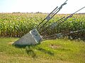
Kotwa wraz z linami odciągowymi
Widok na maszt z ziemi
Zobacz też
Media użyte na tej stronie
Autor: Uwe Dedering, Licencja: CC BY-SA 3.0
Location map of the USA (without Hawaii and Alaska).
EquiDistantConicProjection:
Central parallel:
* N: 37.0° N
Central meridian:
* E: 96.0° W
Standard parallels:
* 1: 32.0° N
* 2: 42.0° N
Made with Natural Earth. Free vector and raster map data @ naturalearthdata.com.
Formulas for x and y:
x = 50.0 + 124.03149777329222 * ((1.9694462586094064-({{{2}}}* pi / 180))
      * sin(0.6010514667026994 * ({{{3}}} + 96) * pi / 180))
y = 50.0 + 1.6155950752393982 * 124.03149777329222 * 0.02613325650382181
      - 1.6155950752393982  * 124.03149777329222 *
     (1.3236744353715044  - (1.9694462586094064-({{{2}}}* pi / 180))
      * cos(0.6010514667026994 * ({{{3}}} + 96) * pi / 180))

The flag of Navassa Island is simply the United States flag. It does not have a "local" flag or "unofficial" flag; it is an uninhabited island. The version with a profile view was based on Flags of the World and as a fictional design has no status warranting a place on any Wiki. It was made up by a random person with no connection to the island, it has never flown on the island, and it has never received any sort of recognition or validation by any authority. The person quoted on that page has no authority to bestow a flag, "unofficial" or otherwise, on the island.
Autor: Alexrk2, Licencja: CC BY 3.0
Ta mapa została stworzona za pomocą GeoTools.

Autor: Oryginalnym przesyłającym był Hephaestos z angielskiej Wikipedii, Licencja: CC-BY-SA-3.0
Pylon supporting KVLY tower (Photo by en:User:Hephaestos August 19, 2003 GFDL)

(c) Ratsbew z angielskiej Wikipedii, CC BY 3.0
KVLY-TV Mast Tower from ground
