Kabru
 | |
| Państwo | |
|---|---|
| Położenie | |
| Pasmo | |
| Wysokość | 7412 m n.p.m. |
| Wybitność | 780 m |
| Pierwsze wejście | 18 listopada 1935 |
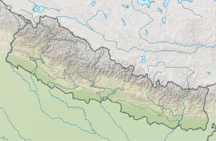
Położenie na mapie Nepalu (c) Karte: NordNordWest, Lizenz: Creative Commons by-sa-3.0 de | |
Kabru – siedmiotysięcznik w paśmie Himalajów. Jest to 65 szczyt Ziemi pod względem wysokości.
Kabru posiada dwa wierzchołki:
- północny, wyższy - Kabru North lub Kabru N, pierwszego wejścia na szczyt dokonał angielski wspinacz Conrad Reginald Cooke (bez dodatkowego tlenu) 18 listopada 1935 r.,
- południowy, niższy - Kabru South lub Kabru S, jest to najbardziej wysunięty na południe siedmiotysięcznik na świecie, pierwszego wejścia na szczyt dokonała ekspedycja indyjska w 1994 r.
Bibliografia
- Kabru. peakware.com. [zarchiwizowane z tego adresu (2012-03-14)].
Media użyte na tej stronie
The Flag of India. The colours are saffron, white and green. The navy blue wheel in the center of the flag has a diameter approximately the width of the white band and is called Ashoka's Dharma Chakra, with 24 spokes (after Ashoka, the Great). Each spoke depicts one hour of the day, portraying the prevalence of righteousness all 24 hours of it.
Black up-pointing triangle ▲, U+25B2 from Unicode-Block Geometric Shapes (25A0–25FF)
(c) Karte: NordNordWest, Lizenz: Creative Commons by-sa-3.0 de
Location map of Nepal including the 7 provinces


