Kafue (rzeka)
| Ten artykuł od 2014-04 wymaga zweryfikowania podanych informacji. |
| ||
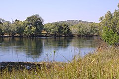
 Rzeka Kafue niedaleko Lubungu, Zambia | ||
| Kontynent | Afryka | |
| Państwo | ||
| Rzeka | ||
| Długość | ok. 1000 km | |
| Źródło | ||
| Współrzędne | 11°37′31,9″S 27°11′19,3″E/-11,625530 27,188700 | |
| Ujście | ||
| Recypient | Zambezi | |
| Współrzędne | 15°56′34,8″S 28°55′02,5″E/-15,943007 28,917358 | |
Kafue – rzeka w Zambii i Demokratycznej Republice Konga o długości ok. 1000 km. Dopływ Zambezi. W jej dorzeczu położony jest Park Narodowy Kafue. Przepływa przez zbiornik Kafue Reservoir.
Zobacz też
- Kafue Gorge Dam
Media użyte na tej stronie
The national flag of the Democratic Republic of the Congo. Created according to the 2006 constitution : Son emblème est le drapeau bleu ciel, orné d’une étoile jaune dans le coin supérieur gauche et traversé en biais d’une bande rouge finement encadrée de jaune. (Its symbol is a sky blue flag, decorated with a yellow star in the upper left corner and crossed in the diagonal by a red strip with thin yellow borders) It seems to be identical, except for a lighter field hue, to the 1966–1971 flag.
Autor: Paulmaz z angielskiej Wikipedii, Licencja: CC-BY-SA-3.0
Kafue river, near Lubungu pontoon, 2001, taken & submitted by Paul Maritz (paulmaz)


