Kaghsi
 | |
| Państwo | |
|---|---|
| Prowincja | Kotajk |
| Populacja (2011) • liczba ludności | 2200 |
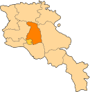
Położenie na mapie Armenii (c) Karte: NordNordWest, Lizenz: Creative Commons by-sa-3.0 de | |
| 40°28′50″N 44°44′28″E/40,480556 44,741111 | |
Kaghsi – wieś w Armenii, w prowincji Kotajk. W 2011 roku liczyła 2200 mieszkańców.
Media użyte na tej stronie
Armenia adm location map.svg
(c) Karte: NordNordWest, Lizenz: Creative Commons by-sa-3.0 de
Location map of Armenia
(c) Karte: NordNordWest, Lizenz: Creative Commons by-sa-3.0 de
Location map of Armenia
Kaghsi.jpg
Autor: 23artashes, Licencja: CC BY-SA 3.0
Kaghsi (Armenian: Քաղսի) is a village in the Kotayk Province of Armenia.
Autor: 23artashes, Licencja: CC BY-SA 3.0
Kaghsi (Armenian: Քաղսի) is a village in the Kotayk Province of Armenia.
Kotayk.svg
Autor:
Image shows the eleven administrative subdivisions of Armenia: # Aragatsotn (Արագածոտնի) # Ararat (Արարատի) # Armavir (Արմավիրի) # Gegharkunik (Գեղարքունիքի) # Kotayk (Կոտայքի) # Lori (Լոռու) # Shirak (Շիրակի) # Syunik (Սյունիքի) # Tavush (Տավուշի) # Vayots Dzor (Վայոց Ձորի) # Yerevan (Երևան) - special administrative status Derived from a multiple of public sources and created using Inkscape. ==
Autor:
- Armenia_map_numbered.svg: Bastique
- derivative work: Varmin (talk)
Image shows the eleven administrative subdivisions of Armenia: # Aragatsotn (Արագածոտնի) # Ararat (Արարատի) # Armavir (Արմավիրի) # Gegharkunik (Գեղարքունիքի) # Kotayk (Կոտայքի) # Lori (Լոռու) # Shirak (Շիրակի) # Syunik (Սյունիքի) # Tavush (Տավուշի) # Vayots Dzor (Վայոց Ձորի) # Yerevan (Երևան) - special administrative status Derived from a multiple of public sources and created using Inkscape. ==


