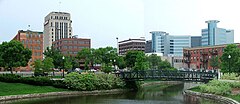
Kalamazoo
 | |
| Państwo | |
|---|---|
| Stan | |
| Hrabstwo | Kalamazoo |
| Burmistrz | Bobby J. Hopewell |
| Powierzchnia | 65,03 km² |
| Wysokość | 239 m n.p.m. |
| Populacja (2000) • liczba ludności • gęstość |
|
| Nr kierunkowy | 269 |
| Kod pocztowy | 49001, 49003, 49004, 49005, 49006, 49007, 49008, 49009, 49019, 49048 |
| Strona internetowa | |
| Portal | |
Kalamazoo – miasto w Stanach Zjednoczonych, w południowo-zachodniej części stanu Michigan, siedziba hrabstwa Kalamazoo, nad rzeką Kalamazoo (uchodzącą do jeziora Michigan). W mieście znajduje się Western Michigan University.

Historia
Założone w 1829 r., prawa miejskie uzyskało w 1883 r. René-Robert Cavelier de La Salle znalazł się w okolicach obecnego miasta w 1680 r. Tornado w roku 1980 zniszczyło centrum miasta, zabijając 5 ludzi i raniąc 79.
Gospodarka
W mieście rozwinął się przemysł drzewny, farmaceutyczny, samochodowy oraz metalowy[2].
Współpraca
Przypisy
- ↑ Kalamazoo (city), Michigan (ang.). United States Census Bureau. [dostęp 2016-01-16].
- ↑ Kalamazoo, [w:] Encyklopedia PWN [online] [dostęp 2021-07-14].
Media użyte na tej stronie
Autor: Uwe Dedering, Licencja: CC BY-SA 3.0
Location map of the USA (without Hawaii and Alaska).
EquiDistantConicProjection:
Central parallel:
* N: 37.0° N
Central meridian:
* E: 96.0° W
Standard parallels:
* 1: 32.0° N
* 2: 42.0° N
Made with Natural Earth. Free vector and raster map data @ naturalearthdata.com.
Formulas for x and y:
x = 50.0 + 124.03149777329222 * ((1.9694462586094064-({{{2}}}* pi / 180))
      * sin(0.6010514667026994 * ({{{3}}} + 96) * pi / 180))
y = 50.0 + 1.6155950752393982 * 124.03149777329222 * 0.02613325650382181
      - 1.6155950752393982  * 124.03149777329222 *
     (1.3236744353715044  - (1.9694462586094064-({{{2}}}* pi / 180))
      * cos(0.6010514667026994 * ({{{3}}} + 96) * pi / 180))
The flag of Navassa Island is simply the United States flag. It does not have a "local" flag or "unofficial" flag; it is an uninhabited island. The version with a profile view was based on Flags of the World and as a fictional design has no status warranting a place on any Wiki. It was made up by a random person with no connection to the island, it has never flown on the island, and it has never received any sort of recognition or validation by any authority. The person quoted on that page has no authority to bestow a flag, "unofficial" or otherwise, on the island.
Flag of Jamaica. “The sunshine, the land is green, and the people are strong and bold” is the symbolism of the colours of the flag. GOLD represents the natural wealth and beauty of sunlight; GREEN represents hope and agricultural resources; BLACK represents the strength and creativity of the people. The original symbolism, however, was "Hardships there are, but the land is green, and the sun shineth", where BLACK represented the hardships being faced.
Flag of New Zealand. Specification: http://www.mch.govt.nz/nzflag/description.html , quoting New Zealand Gazette, 27 June 1902.
Autor: M. D. Woods-deWitt, Licencja: CC-BY-SA-3.0
Amtrak #352 eastbound from Chicago to Pontiac on approach to Kalamazoo station.
Autor: Alexrk2, Licencja: CC BY 3.0
Ta mapa została stworzona za pomocą GeoTools.
Looking southwest from N. Edwards Street in downtown Kalamazoo, Michigan. Round-topped towers are the Radisson Plaza hotel.


