Kalitea
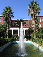
 Główny budynek Uniwersytetu Pandio | |
| Państwo | |
|---|---|
| Administracja zdecentralizowana | |
| Region | |
| Jednostka regionalna | |
| Gmina | |
| Populacja (2011) • liczba ludności |
|
| Nr kierunkowy | 210 |
| Kod pocztowy | 176 xx |
Położenie na mapie Grecji (c) Lencer, CC BY-SA 3.0 | |
| Strona internetowa | |
Kalitea (gr. Καλλιθέα) – miasto w Grecji, w administracji zdecentralizowanej Attyka, w regionie Attyka, w jednostce regionalnej Ateny-Sektor Południowy, położone w granicach Wielkich Aten, siedziba i jedyna miejscowość gminy Kalitea, ośrodek przemysłu spożywczego i włókienniczego.
W 2011 roku liczyło 100 641 mieszkańców[1].
Przypisy
Media użyte na tej stronie
Autor: Nikolaos Diakidis (user: Nik7), Licencja: CC BY-SA 3.0 de
The first, historic building of Panteion University of Social and Political Sciences (located in Athens, Greece), in which nowadays are housed the university’s central administrative departments, the Rector’s office, and the library. The building’s foundation stone was ceremonially laid on January 2, 1927 by the first President of the Second Hellenic Republic, Admiral Pavlos Kountouriotis. Classes began three years later, on November 18, 1930, in the presence of the eighth Prime Minister of the Second Hellenic Republic, Eleftherios Venizelos, who was one of Panteion University’s first donors and benefactors.
(c) Lencer, CC BY-SA 3.0
Location map of Greece
Equirectangular projection, N/S stretching 120 %. Geographic limits of the map:
- N: 42.0° N
- S: 34.6° N
- W: 19.1° E
- E: 29.9° E


