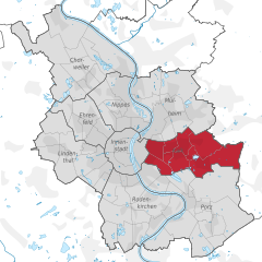
Kalk (okręg administracyjny Kolonii)
| okręg administracyjny | |||
 | |||
| |||
| Państwo | |||
|---|---|---|---|
| Kraj związkowy | Kolonia | ||
| Powierzchnia | 16,37 km² | ||
| Populacja (31 grudnia 2012) • liczba ludności | 127 827 | ||
| • gęstość | 7 809 os./km² | ||
| Tablice rejestracyjne | K | ||
Adres urzędu: Laurenzplatz 1–3, 50667 Köln | |||
Położenie na mapie | |||
| 50°56′N 6°57′E/50,933333 6,950000 | |||
| Strona internetowa | |||
| Portal | |||
Kalk, Köln-Kalk – okręg administracyjny (niem. Stadtbezirk) w Kolonii, w Niemczech, w kraju związkowym Nadrenia Północna-Westfalia.
W skład okręgu administracyjnego wchodzi dziewięć dzielnic (Stadtteil):
Bibliografia
Media użyte na tej stronie
„Per fess azure und Argent, a porched chapel Argent with ridge turret, thereupon a flag Or; below, an wooden block proper issuant, thereupon a gear and an anvil sable, behind them saltirewise hammer and pick sable with handles proper; a five-topped mural cown gules in the crest.“
The arms show the old Kalk chapel combined with industry tools of the 19th century.


