Kapisa
| prowincja | |
 | |
| Państwo | |
|---|---|
| Siedziba | Mahmud-i-Raqi |
| Kod ISO 3166-2 |
|
| Populacja (2021) • liczba ludności |
|
| Plan | |
 | |
Położenie na mapie Afganistanu | |
Kapisa (paszto/perski: کاپيسا) – prowincja we wschodnim Afganistanie. Jej stolicą jest Mahmud-i-Raqi. Powierzchnia wynosi 1842 km², a populacja w 2021 wyniosła prawie 500 tys. mieszkańców[1]. Głównym językiem jest dari.
Składa się z 7 dystryktów:
- Alasaj
- Hesa Duwum Kohistan
- Koh Band
- Kohistan Hesa Awal
- Mahmud-i-Raqi
- Nidżrab
- Tagab
Przypisy
- ↑ Estimated Population of Afghanistan 2021-22. [dostęp 2021-08-27]. [zarchiwizowane z tego adresu (2021-08-19)].
Media użyte na tej stronie
Autor: TUBS
Location of province XY (see filename) in Afghanistan
Map of the districts of Kapisa province of Afghanistan. Created by Rarelibra 19:26, 29 March 2007 (UTC) for public domain use, using MapInfo Professional v8.5 and various mapping resources.
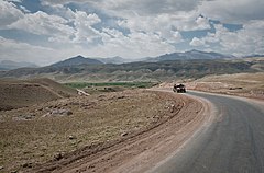
KAPISA PROVINCE, Afghanistan (March 30, 2010) —A humvee of the Afghan National Army traverses a solitary road through the Tagab Valley. (U.S. Navy photo by Petty Officer 1st Class Mark O’Donald/Released)


