Karnulu (dystrykt)
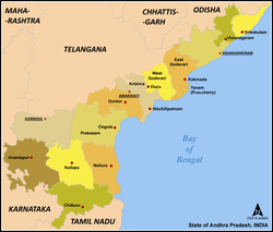
Karnulu (dystrykt) – jeden z dwudziestu trzech dystryktów indyjskiego stanu Andhra Pradesh, o powierzchni 17 700 km². Populacja tego dystryktu wynosi 3 524 073 osób (2004), stolicą jest miasto Karnulu.
Położenie
Na zachodzie graniczy ze stanem Karnataka, od północy z dystryktem Mahabubnagar, od wschodu z Prakasam a na południu sąsiaduje z dystryktami Anantapur i Kadapa.
Bibliografia
- Andhra Pradesh Road Atlas & State Distance Guide. R.P.Arya (red.). Dźodhpur: Indian Map Service, 2005. ISBN 81-87460-07-5. (ang.)
Media użyte na tej stronie
Autor:
This Image was created by User:PlaneMad.
|
Autor: Autor nie został podany w rozpoznawalny automatycznie sposób. Założono, że to Miljoshi (w oparciu o szablon praw autorskich)., Licencja: CC-BY-SA-3.0
Map of w:Andhra Pradesh, India with district boundaries - add districts shaded.


