Katastrofa lotu Caspian Airlines 7908
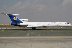
 Tu-154, który uległ katastrofie (nr rej. EP-CPG). Zdjęcie wykonano na lotnisku w Dubaju w listopadzie 2008 roku. | |
| Państwo | |
|---|---|
| Miejsce | Kazwin |
| Data | |
| Godzina | 11:33 czasu lokalnego |
| Rodzaj | Zderzenie z ziemią. |
| Przyczyna | Usterka mechaniczna wskutek zderzenia z ptakiem |
| Ofiary | 168 osób |
| Ranni | 0 osób |
| Statek powietrzny | |
| Typ | |
| Użytkownik | |
| Numer | EP-CPG |
| Start | |
| Cel lotu | |
| Numer lotu | 7908 |
| Pasażerowie | 153 osoby |
| Załoga | 15 osób |
Katastrofa lotu Caspian Airlines 7908 – katastrofa, do której doszło 15 lipca 2009 roku z udziałem pasażerskiego samolotu Tupolew Tu154M. Na pokładzie maszyny było 153 pasażerów i 15-osobowa załoga[1] – wszystkie osoby zginęły na miejscu.
Samolot należący do irańskich linii lotniczych Caspian Airlines lecący z Teheranu do armeńskiego Erywania rozbił się o ziemię podczas awaryjnego lądowania 16 minut po starcie.
Pasażerowie
| Narodowość | Pasażerowie | Załoga | Razem |
|---|---|---|---|
| 141[2] | 13 | 154 | |
| 4[2] | 2[2] | 6 | |
| 2 | 2 | ||
| 2[2] | 2 | ||
| 2[3] | 2 | ||
| 2 | 2 | ||
| Razem: | 153[2] | 15[2] | 168 |
Zobacz też
Linki zewnętrzne
- "Meeting Notes Moscow IAC July 6, 2010." (Archive) Iran Civil Aviation Organization. (EN)
- "Ту-154М EP-CPG 15.07.2009." (Archive) Międzypaństwowy Komitet Lotniczy. (RU)
Przypisy
- ↑ BBC News - Scores killed in Iran plane crash, news.bbc.co.uk [dostęp 2017-11-24] (ang.).
- ↑ a b c d e f «Un avion de Caspian Airlines s'écrase» Challenges.fr
- ↑ «2 canadiens étaient à bord»
Bibliografia
- "Samolot był sprawny". Dlaczego doszło do katastrofy?. tvn24.pl. [dostęp 2009-07-15]. [zarchiwizowane z tego adresu (16 lipca 2009)].
Media użyte na tej stronie
Autor: Uwe Dedering, Licencja: CC BY-SA 3.0
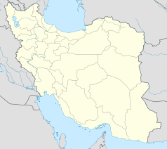
Location map of Iran.
Equirectangular projection. Stretched by 118.0%. Geographic limits of the map:
* N: 40.0° N
* S: 24.5° N
* W: 43.5° E
* E: 64.0° E
Made with Natural Earth. Free vector and raster map data @ naturalearthdata.com.
The flag of Navassa Island is simply the United States flag. It does not have a "local" flag or "unofficial" flag; it is an uninhabited island. The version with a profile view was based on Flags of the World and as a fictional design has no status warranting a place on any Wiki. It was made up by a random person with no connection to the island, it has never flown on the island, and it has never received any sort of recognition or validation by any authority. The person quoted on that page has no authority to bestow a flag, "unofficial" or otherwise, on the island.
Autor:


