Katastrofa lotu United Airlines 175
 Lot UA175 z Bostonu do Nowego Jorku. | |
| Państwo | |
|---|---|
| Miejsce | |
| Data | 11 września 2001 |
| Godzina | 9:03 czasu lokalnego |
| Rodzaj | zderzenie z budynkiem |
| Przyczyna | celowy lot ku ziemi, atak samobójczy |
| Ofiary | 60 osób |
| Ocaleni | 0 osób |
| Statek powietrzny | |
| Typ | |
| Użytkownik | |
| Numer | N612UA |
| Start | |
| Cel lotu | |
| Numer lotu | 175 |
| Pasażerowie | 51 osób |
| Załoga | 9 osób |
| Ofiary | 60 osób |
Położenie na mapie Manhattanu  | |
Położenie na mapie Stanów Zjednoczonych  | |
Położenie na mapie stanu Nowy Jork  (c) NordNordWest, CC BY 3.0 | |
Położenie na mapie Nowego Jorku  | |
United Airlines Lot 175 (ang. United Airlines Flight 175) – drugi porwany samolot podczas zamachu z 11 września 2001 roku. Był to wyprodukowany w 1983 roku Boeing 767 linii lotniczych United Airlines, którego lot rozpoczął się z portu lotniczego Boston, a miał zakończyć się w porcie lotniczym Los Angeles. Po ponad dwudziestu ośmiu minutach po starcie terroryści siłą przedostali się do kokpitu. Przejęli oni kontrolę nad samolotem i o godzinie 9:03 lokalnego czasu uderzyli nim w Wieżę Południową World Trade Center. W wyniku katastrofy zginęli wszyscy pasażerowie samolotu: łącznie 60 osób (46 pasażerów, 9 członków załogi i 5 porywaczy)[1].
Galeria
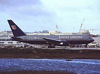
Porwany Boeing 767 w 1999 roku
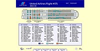
Lista pasażerów i porywaczy, oraz ich miejsca samolocie
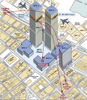
Schemat uderzenia samolotów w World Trade Center
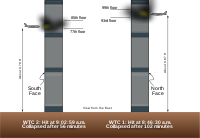
Schemat uderzenia samolotów w bliźniacze wieże WTC
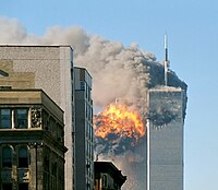
Eksplozja samolotu linii United Airlines w momencie uderzenia w południową wieżę WTC

Wieża Południowa WTC po uderzeniu samolotu
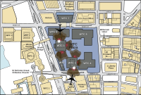
Schemat uderzeń samolotów w wieżę WTC i rozmieszczenie ich szczątków
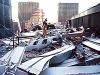
Fragment kadłuba samolotu

Szczątki silnika lotu 175
Zobacz też
Przypisy
Media użyte na tej stronie
Autor: Uwe Dedering, Licencja: CC BY-SA 3.0
Location map of the USA (without Hawaii and Alaska).
EquiDistantConicProjection:
Central parallel:
* N: 37.0° N
Central meridian:
* E: 96.0° W
Standard parallels:
* 1: 32.0° N
* 2: 42.0° N
Made with Natural Earth. Free vector and raster map data @ naturalearthdata.com.
Formulas for x and y:
x = 50.0 + 124.03149777329222 * ((1.9694462586094064-({{{2}}}* pi / 180))
      * sin(0.6010514667026994 * ({{{3}}} + 96) * pi / 180))
y = 50.0 + 1.6155950752393982 * 124.03149777329222 * 0.02613325650382181
      - 1.6155950752393982  * 124.03149777329222 *
     (1.3236744353715044  - (1.9694462586094064-({{{2}}}* pi / 180))
      * cos(0.6010514667026994 * ({{{3}}} + 96) * pi / 180))
(c) NordNordWest, CC BY 3.0
Location map of the State of New York, USA
Autor: Alexrk2, Licencja: CC BY 3.0
Ta mapa została stworzona za pomocą GeoTools.

The flag of Navassa Island is simply the United States flag. It does not have a "local" flag or "unofficial" flag; it is an uninhabited island. The version with a profile view was based on Flags of the World and as a fictional design has no status warranting a place on any Wiki. It was made up by a random person with no connection to the island, it has never flown on the island, and it has never received any sort of recognition or validation by any authority. The person quoted on that page has no authority to bestow a flag, "unofficial" or otherwise, on the island.
.jpg)
WTC burning on 9/11.
.svg)
Illustrative guide to the relative positioning of the planes that caused the 9/11 disaster.
Autor: , Licencja: CC BY-SA 2.0

Autor: FBI, Licencja: CC BY-SA 4.0
Auszug aus einer Flash-Präsentation, welche im Gerichtsverfahren United States vs. Zacarias Moussaoui (Nr. 01-455-A) verwendet wurde (http://www.vaed.uscourts.gov/notablecases/moussaoui/exhibits/prosecution/flights/P200055.html).

Autor: Ctac, Licencja: CC BY-SA 3.0
Airplane engine parts from American Airlines Flight 11 and United Airlines Flight 175, which hit the World Trade Center's North and South Tower, respectively. Loan, FBI Tour. Newseum, Washington D.C., USA.

A portion of the fuselage of United Airlines Flight 175 on the roof of WTC 5.

Autor:
- UA_Flight_175_hits_WTC_south_tower_9-11.jpeg: Flickr user TheMachineStops (Robert J. Fisch)
- derivative work: upstateNYer
United Airlines Flight 175 crashes into the south tower of the World Trade Center complex in New York City during the September 11 attacks

Autor: Cflm001 (dyskusja), Licencja: CC BY-SA 3.0
A diagram showing the areas where debris from American Airlines Flight 11 and United Airlines Flight 175 fell upon Lower Manhattan during the course of the September 11 terror attacks.

Autor: MesserWoland, Licencja: CC-BY-SA-3.0
An illustration of the World Trade Center 9-11 Attacks with a horizontal view of the impact locations.

Autor:
N612UA, the Boeing 767-200 hijacked as United Airlines Flight 175 during the September 11, 2001 attacks, taxiing at San Francisco International Airport in December 1999.