Katedra w Chester
| |||||||||
| katedra | |||||||||
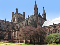
 widok od strony wschodniej | |||||||||
| Państwo | |||||||||
| Kraj | |||||||||
| Miejscowość | Chester | ||||||||
| Wyznanie | anglikanizm | ||||||||
| Kościół | Kościół Anglii | ||||||||
| |||||||||
| |||||||||
Położenie na mapie Cheshire Contains Ordnance Survey data © Crown copyright and database right, CC BY-SA 3.0 | |||||||||
Położenie na mapie Wielkiej Brytanii (c) Karte: NordNordWest, Lizenz: Creative Commons by-sa-3.0 de | |||||||||
Katedra w Chester (ang. Chester Cathedral, pełna nazwa Cathedral Church of Christ and the Blessed Virgin Mary, Kościół katedralny Chrystusa i Najświętszej Maryi Panny) – katedra diecezji Chester Kościoła Anglii.
Kościół katedralny i kaplice, kapitularz, budynki administracyjne i gospodarcze byłego opactwa benedyktynów Świętego Werburgha. Na miejscu anglosaskiego klasztoru założonego przed 958 rokiem, obecna budowla datowana jest na XI wiek (czasy opata Richarda); XII wiek, XII wiek; 1260-1280 (czasy opata Simona z Whitchurch); XIV wiek; późny XV wiek (czasy opata Simona Ripleya); wczesny XVI wiek; wczesny XVII wiek (czasy biskupa Bridgemana); 1818-1820 (architekt Thomas Harrison); 1844 i później (architekt R.C. Hussey); 1868 i później architekt sir George Gilbert Scott i jego syn George; 1882 i później (architekci sir Arthur Blomfield i C. J. Blomfield); 1911-1913 (architekt sir Giles Gilbert Scott) i 1939 (architekt F.H. Crossley); wolnostojąca dzwonnica została wzniesiona w latach 1974–1975 przez G.G. Pace’a.
Bibliografia
Media użyte na tej stronie
(c) Karte: NordNordWest, Lizenz: Creative Commons by-sa-3.0 de
Location map of the United Kingdom
Blue Shield - the Distinctive emblem for the Protection of Cultural Property. The distinctive emblem is a protective symbol used during armed conflicts. Its use is restricted under international law.
Flag of England. Saint George's cross (a red cross on a white background), used as the Flag of England, the Italian city of Genoa and various other places.
Contains Ordnance Survey data © Crown copyright and database right, CC BY-SA 3.0
Map of Cheshire, UK with the following information shown:
- Administrative borders
- Coastline, lakes and rivers
- Roads and railways
- Urban areas
Equirectangular map projection on WGS 84 datum, with N/S stretched 165%
Geographic limits:
- West: 3.15W
- East: 1.95W
- North: 53.50N
- South: 52.94N
Autor: Stephen Hamilton, Licencja: CC BY-SA 3.0
Chester Cathedral, England. The cathedral seen from the south-east looking towards the choir, right, with the Lady Chapel projecting, extreme right, and the south transept, left. The Lady Chapel is in the Early English (or Lancet) Gothic style, marked by the simple windows. The choir is in the late Geometric Decorated Gothic style. The South transept has Flowing Decorated windows in the aisle, and Perpendicular Gothic windows in the clerestory. The friable Red Sandstone building was heavily restored in the 19th century.


