Katedra w Exeter
| |||||||
| katedra | |||||||
| Państwo | |||||||
| Miejscowość | Exeter | ||||||
| Wyznanie | protestanckie | ||||||
| Kościół | Anglii | ||||||
| Imię | św. Piotra | ||||||
| |||||||
Położenie na mapie Exeteru Contains Ordnance Survey data © Crown copyright and database right, CC BY-SA 3.0 | |||||||
Położenie na mapie Wielkiej Brytanii (c) Karte: NordNordWest, Lizenz: Creative Commons by-sa-3.0 de | |||||||
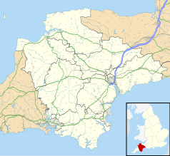
Położenie na mapie Devonu Contains Ordnance Survey data © Crown copyright and database right, CC BY-SA 3.0 | |||||||
Katedra świętego Piotra w Exeter. Budowę katedry rozpoczęli Normanowie w 1114, a najstarszą zachowaną częścią budowli są wieże katedry. W 1270 biskup Walter Branscombe rozpoczął trwający 90 lat proces przebudowy katedry. Zachodnia ściana katedry ozdobiona jest największą kolekcją XIV-wiecznych rzeźb. Wewnątrz można podziwiać najdłuższe, zachowane gotyckie sklepienie na świecie. W północnym transepcie działa XV-wieczny zegar astronomiczny prezentujący ówcześnie obowiązująca geocentryczną budowę wszechświata.
Bibliografia
- Praca zbiorowa: Lonely Planet England. Wyd. V. Lonely Planet, 2008, s. 375. ISBN 978-174-10459-01.
Media użyte na tej stronie
(c) Karte: NordNordWest, Lizenz: Creative Commons by-sa-3.0 de
Location map of the United Kingdom
Contains Ordnance Survey data © Crown copyright and database right, CC BY-SA 3.0
Map of Devon, UK with the following information shown:
- Administrative borders
- Coastline, lakes and rivers
- Motorways and primary routes
- Urban areas
Equirectangular map projection on WGS 84 datum, with N/S stretched 150%
Geographic limits:
- West: 4.72W
- East: 2.86W
- North: 51.3N
- South: 50.16N
Blue Shield - the Distinctive emblem for the Protection of Cultural Property. The distinctive emblem is a protective symbol used during armed conflicts. Its use is restricted under international law.
(c) Dietmar Rabich, CC BY-SA 4.0
This is a photo of listed building number 1333352.
Contains Ordnance Survey data © Crown copyright and database right, CC BY-SA 3.0
Map of Exeter, Devon, UK with electoral wards as of 2016 shown.
Equirectangular map projection on WGS 84 datum, with N/S stretched 150%
Geographic limits:
- West: 3.58W
- East: 3.45W
- North: 50.77N
- South: 50.66N


