Katedra w Gloucester
| katedra | |||||||||||
 Widok na fasadę świątyni | |||||||||||
| Państwo | |||||||||||
|---|---|---|---|---|---|---|---|---|---|---|---|
| Kraj | |||||||||||
| Miejscowość | |||||||||||
| Wyznanie | |||||||||||
| Kościół | |||||||||||
| |||||||||||
| |||||||||||
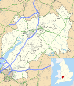
Położenie na mapie Gloucestershire Contains Ordnance Survey data © Crown copyright and database right, CC BY-SA 3.0 | |||||||||||
Położenie na mapie Wielkiej Brytanii (c) Karte: NordNordWest, Lizenz: Creative Commons by-sa-3.0 de | |||||||||||
| Strona internetowa | |||||||||||
Katedra w Gloucester (ang. Cathedral Church of St Peter and the Holy and Indivisible Trinit) – katedra anglikańska w Gloucester. Konstrukcja katedry jest trójnawowa z transeptem z obejściem chóru i wieńcem kaplic.
Budowa świątyni rozpoczęła się w lipcu 1084 z inicjatywy opata Serlo na ruinach kościoła św. Piotra, który spłonął w 1058 roku. Budowę zakończono w 1218 roku.
Bibliografia
- Praca zbiorowa: Sztuka Romańska. red. Rolf Toman. Tandem Verlag GmBH, 2008, s. 230-231. ISBN 978-83-7512-972-4.
Media użyte na tej stronie
(c) Karte: NordNordWest, Lizenz: Creative Commons by-sa-3.0 de
Location map of the United Kingdom
Blue Shield - the Distinctive emblem for the Protection of Cultural Property. The distinctive emblem is a protective symbol used during armed conflicts. Its use is restricted under international law.
Flag of England. Saint George's cross (a red cross on a white background), used as the Flag of England, the Italian city of Genoa and various other places.
Autor: Christopher JT Cherrington, Licencja: CC BY-SA 4.0
This is a photo of listed building number 1245954.
Contains Ordnance Survey data © Crown copyright and database right, CC BY-SA 3.0
Map of Gloucestershire, UK with the following information shown:
- Administrative borders
- Coastline, lakes and rivers
- Roads and railways
- Urban areas
Equirectangular map projection on WGS 84 datum, with N/S stretched 160%
Geographic limits:
- West: 2.70W
- East: 1.60W
- North: 52.16N
- South: 51.36N
Autor: Saffron Blaze, Licencja: CC BY-SA 3.0
This is a photo of listed building number 1245952.


