Katedra w Guildford
| |||||||||
| katedra | |||||||||
 widok ogólny | |||||||||
| Państwo | |||||||||
| Kraj | |||||||||
| Miejscowość | Guildford | ||||||||
| Wyznanie | anglikanizm | ||||||||
| Kościół | Kościół Anglii | ||||||||
| |||||||||
| |||||||||
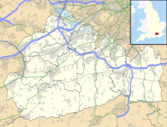
Położenie na mapie Surrey Contains Ordnance Survey data © Crown copyright and database right, CC BY-SA 3.0 | |||||||||
Położenie na mapie Wielkiej Brytanii (c) Karte: NordNordWest, Lizenz: Creative Commons by-sa-3.0 de | |||||||||
Katedra w Guildford (ang. Guildford Cathedral, pełna nazwa Cathedral Church of the Holy Spirit, Kościół katedralny Świętego Ducha) – katedra diecezji Guildford Kościoła Anglii.
Kościół został zaprojektowany w latach 1932–1933 przez Edwarda Maufe'go. kamień węgielny został położony w 1936 roku. Wschodnia część budowli została ukończona w 1936 roku. Drugi etap budowy został rozpoczęty w 1948 roku. Nawa główna została ukończona w 1955 roku. Katedra została poświęcona w 1961 roku. Kapitularz został ukończony w 1964 roku. Zachodni dziedziniec ukończony w latach 1964–1965. Świątynia została wzniesiona w zmodyfikowanym stylu neogotyckim z wpływami stylu art déco.
Bibliografia
Media użyte na tej stronie
(c) Karte: NordNordWest, Lizenz: Creative Commons by-sa-3.0 de
Location map of the United Kingdom
Blue Shield - the Distinctive emblem for the Protection of Cultural Property. The distinctive emblem is a protective symbol used during armed conflicts. Its use is restricted under international law.
Flag of England. Saint George's cross (a red cross on a white background), used as the Flag of England, the Italian city of Genoa and various other places.
Photograph taken (Feb 2006) and uploaded by en:User:Purple. I release this photograph to the public domain.
Contains Ordnance Survey data © Crown copyright and database right, CC BY-SA 3.0
Map of Surrey, UK with the following information shown:
- Administrative borders
- Coastline, lakes and rivers
- Roads and railways
- Urban areas
Equirectangular map projection on WGS 84 datum, with N/S stretched 160%
Geographic limits:
- West: 0.87W
- East: 0.08E
- North: 51.50N
- South: 51.05N


