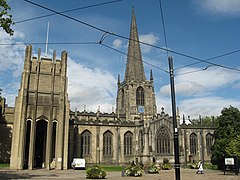
Katedra w Sheffield
| katedra | |||||||||
(c) Richard Rogerson, CC BY-SA 2.0 widok ogólny | |||||||||
| Państwo | |||||||||
|---|---|---|---|---|---|---|---|---|---|
| Kraj | |||||||||
| Miejscowość | |||||||||
| Wyznanie | |||||||||
| Kościół | |||||||||
| |||||||||
| |||||||||
Położenie na mapie Sheffield Contains Ordnance Survey data © Crown copyright and database right, CC BY-SA 3.0 | |||||||||
Położenie na mapie Wielkiej Brytanii (c) Karte: NordNordWest, Lizenz: Creative Commons by-sa-3.0 de | |||||||||
Położenie na mapie South Yorkshire Contains Ordnance Survey data © Crown copyright and database right, CC BY-SA 3.0 | |||||||||
Katedra w Sheffield (ang. Sheffield Cathedral, lub Cathedral Church of St Peter and St Paul) – katedra Kościoła Anglii znajdująca się w Sheffield. Pierwotnie był to kościół parafialny, godność katedry uzyskał w 1914 roku, gdy utworzono diecezję Sheffield.
Wieża przy skrzyżowaniu naw, iglica, prezbiterium i kaplice prezbiterium powstały około 1430 roku. Shrewsbury prezbiterium kaplicy 1520. Północna kaplica prezbiterium przebudowana na zakrystię w 1777 roku przez Thomasa Atkinsona i zamieniona na kaplicę w 1914 roku. Nawa główna i na wschodni kraniec przebudowane w latach 1790–1805, zapewne przez Johna Carra. Nawa główna została przedłużona i zostały dodane transepty w 1810 roku. Świątynia została odrestaurowana w 1841 roku przez Roberta Pottera. Transepty, arkady w nawie głównej, zachodni kraniec, oraz wschodnie okna przebudowane i odrestaurowane w 1880 roku przez Williama Flocktona. Kapitularz, biuro parafialne, i kaplica Ducha Świętego wybudowane w latach 1936-48 przez Sir Charlesa Nicholsona. Kruchta, łącznik i zachodni kraniec wzniesione w latach 1960-66 przez GG Pace i Ansell & Bailey. Mur ciosowy, dach ołowiany. Elementy sprzed 1880 roku zostały wykonane w stylu Perpendicular Style. Elementy dodane przez Nicholsona zostały wykonane w stylu Decorated Style. Elementy dodane w latach 60. XX wieku zostały wykonane w stylu Free Gothic.
Bibliografia
Media użyte na tej stronie
(c) Karte: NordNordWest, Lizenz: Creative Commons by-sa-3.0 de
Location map of the United Kingdom
Contains Ordnance Survey data © Crown copyright and database right, CC BY-SA 3.0
Map of South Yorkshire, UK with the following information shown:
- Administrative borders
- Coastline, lakes and rivers
- Roads and railways
- Urban areas
Equirectangular map projection on WGS 84 datum, with N/S stretched 165%
Geographic limits:
- West: 1.84W
- East: 0.85W
- North: 53.67N
- South: 53.26N
Blue Shield - the Distinctive emblem for the Protection of Cultural Property. The distinctive emblem is a protective symbol used during armed conflicts. Its use is restricted under international law.
Flag of England. Saint George's cross (a red cross on a white background), used as the Flag of England, the Italian city of Genoa and various other places.
Contains Ordnance Survey data © Crown copyright and database right, CC BY-SA 3.0
Map of Sheffield, South Yorkshire, UK with electoral wards shown.
Equirectangular map projection on WGS 84 datum, with N/S stretched 165%
Geographic limits:
- West: 1.82W
- East: 1.30W
- North: 53.51N
- South: 53.29N
(c) Richard Rogerson, CC BY-SA 2.0
The Anglican Cathedral Church of St Peter and St Paul, Sheffield, South Yorkshire, England. There has been a church on this site since Saxon times. It has always been a parish church, and since 1914 it has been the Cathedral Church of the Diocese of Sheffield. It is Grade 1 Listed. Official website


