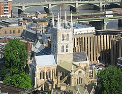
Katedra w Southwark
| katedra | |||||||||
(c) Kevin Danks, CC BY-SA 2.0 widok ogólny | |||||||||
| Państwo | |||||||||
|---|---|---|---|---|---|---|---|---|---|
| Kraj | |||||||||
| Miejscowość | |||||||||
| Wyznanie | |||||||||
| Kościół | |||||||||
| |||||||||
| |||||||||
Położenie na mapie gminy Southwark Contains Ordnance Survey data © Crown copyright and database right, CC BY-SA 3.0 | |||||||||
Położenie na mapie Wielkiej Brytanii (c) Karte: NordNordWest, Lizenz: Creative Commons by-sa-3.0 de | |||||||||
Położenie na mapie Wielkiego Londynu Contains Ordnance Survey data © Crown copyright and database right, CC BY-SA 3.0 | |||||||||
Katedra w Southwark (ang. Southwark Cathedral, lub The Cathedral and Collegiate Church of St Saviour and St Mary Overie) – katedra Kościoła Anglii znajdująca się w Londynie, w dzielnicy Southwark. Mieści się na południowym brzegu rzeki Tamizy, blisko mostu London Bridge. Jest kościołem matką dla diecezji Southwark. Od przeszło 1000 lat jest miejscem kultu chrześcijańskiego, ale godność katedry posiada dopiero od 1905 roku, gdy utworzono wspomnianą wyżej diecezję.
W latach 1106–1538 katedra była kościołem klasztornym augustianów, zwanym Southwark Priory, poświęconym Najświętszej Maryi Pannie. Po rozwiązaniu klasztorów, świątynia otrzymała godność kościoła parafialnego i nowe wezwanie świętego Zbawiciela. Kościół należał do diecezji Winchesteru do 1877 roku, kiedy to parafia świętego Zbawiciela razem z innymi parafiami południowego Londynu została włączona do diecezji Rochester. Obecna budowla zachowała podstawową formę gotyckiej konstrukcji, wzniesionej w latach 1220–1420, chociaż nawa główna jest efektem przebudowy wykonanej w XIX wieku.
Bibliografia
- Southwark Cathedral - Visit us - History and Architecture. cathedral.southwark.anglican.org. [zarchiwizowane z tego adresu (2015-04-28)].
Media użyte na tej stronie
(c) Karte: NordNordWest, Lizenz: Creative Commons by-sa-3.0 de
Location map of the United Kingdom
Contains Ordnance Survey data © Crown copyright and database right, CC BY-SA 3.0
Map of Greater London, UK with the following information shown:
- Administrative borders
- Coastline, lakes and rivers
- Roads and railways
- Urban areas
The data includes both primary routes and railway lines.
Equirectangular map projection on WGS 84 datum, with N/S stretched 160%
Geographic limits:
- West: 0.57W
- East: 0.37E
- North: 51.72N
- South: 51.25N
Blue Shield - the Distinctive emblem for the Protection of Cultural Property. The distinctive emblem is a protective symbol used during armed conflicts. Its use is restricted under international law.
Flag of England. Saint George's cross (a red cross on a white background), used as the Flag of England, the Italian city of Genoa and various other places.
(c) Kevin Danks, CC BY-SA 2.0
Southwark Cathedral. Taken from the 24th floor of an office building above London Bridge station.
Contains Ordnance Survey data © Crown copyright and database right, CC BY-SA 3.0
Blank map of the London Borough of Southwark, showing electoral wards.
Equirectangular map projection on WGS 84 datum, with N/S stretched 160%
Geographic limits:
- West: 0.13W
- East: 0.01W
- North: 51.515N
- South: 51.415N


