Katedra w St Albans
 Katedra w St Albans | |||||||||||
| Państwo | |||||||||||
|---|---|---|---|---|---|---|---|---|---|---|---|
| Miejscowość | |||||||||||
| Wyznanie | |||||||||||
| Kościół | |||||||||||
| Imię | |||||||||||
| |||||||||||
| |||||||||||
Położenie na mapie Hertfordshire Contains Ordnance Survey data © Crown copyright and database right, CC BY-SA 3.0 | |||||||||||
Położenie na mapie Wielkiej Brytanii (c) Karte: NordNordWest, Lizenz: Creative Commons by-sa-3.0 de | |||||||||||


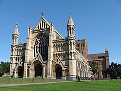
Katedra w St Albans (ang. St Albans Cathedral, oficjalnie Cathedral and Abbey Church of St Alban – Katedra i Kościół Opactwa pw. św. Albana) – wybudowana w latach 1077–1893 katedra Kościoła Anglii w St Albans w hrabstwie Hertfordshire w Anglii. Katedra jest siedzibą diecezji St Albans, należącej do prowincji Canterbury.
Kościół katedralny wybudowany został na wzgórzu zwanym Holmhurst Hill (dzisiejsza nazwa wzgórza i drogi prowadzącej do katedry to Holywell Hill). Wcześniej, od VIII wieku, na wzgórzu istniał klasztor benedyktynów ufundowany przez Offę, króla Mercji. W wyniku badań archeologicznych najstarsze dostępne pozostałości klasztoru wydatowano na rok 793. Kościół katedralny do dziś popularnie zwany jest przez mieszkańców miasta opactwem (the Abbey), mimo że klasztor już nie istnieje.
W kościele znajduje się kaplica i grobowiec św. Albana, męczennika który został patronem katedry i od którego imienia pochodzi współczesna nazwa miasta. W roku 2002 zaprezentowano łopatkę – relikwię świętego, która obecnie znajduje się w grobowcu[1].
Architektura
Katedra łączy w sobie style romański oraz gotycki.
Do zbudowania kościoła wtórnie użyto wapienia z Lincolnshire (Barnack stone), pochodzącego z pobliskich ruin rzymskiego miasta Verulamium. Wykorzystano także kamień Totternhoe z Bedfordshire, marmur z Purbeck oraz różne gatunki lokalnego wapienia: Ancaster, Chilmark, Clipsham itd.
Wymiary
- Długość: 167,8m
- Długość (nawa): 84m
- Szerokość z transeptami: 58.5m[2]
- Szerokość (nawa): 23m
- Wysokość maksymalna: 43,9m
- Wysokość (nawa): 20.2m
- Liczba wież: 1
- Wysokość wieży: 43,9m[3]
- Powierzchnia: 4 900m²[3]
84-metrowa nawa katedry w St Albans jest najdłuższą nawą w Anglii.
Nabożeństwa
Katedra pełni funkcję ekumeniczną. Odbywają się tu nabożeństwa: anglikańskie, rzymskokatolickie, prawosławne, luterańskie (w języku niemieckim) oraz ogólnochrześcijańskie[4].
Międzynarodowy Festiwal Organowy
Od roku 1963 w katedrze odbywa się Międzynarodowy Festiwal Organowy w St Albans (ang. St Albans International Organ Festival), wśród laureatów znaleźli się Dame Gillian Weir, Thomas Trotter oraz Naji Hakim.
Pochówki
W katedrze i na przykościelnym cmentarzu pochowani zostali m.in.:
- Thomas de la Mare (zm. 1396), opat
- John Whethamstede (zm. 1465), opat
- Thomas Clifford, VIII Baron de Clifford (1414–1455)
- Edmund Beckett, I Baron Grimthorpe
- Robert „of the Chamber” Breakspear (zm. 1110), ksiądz w diecezji w Bath, później mnich w St Albans; ojciec Nicholasa, który został jedynym pochodzącym z Wielkiej Brytanii papieżem znanym jako Hadrian IV.
- Thomas Legh Claughton, pierwszy biskup St Albans (1877–1890), pochowany przy kościele.
- Robert Runcie, biskup St Albans (1970–1980), Arcybiskup Canterbury 1980–1991, pochowany przy kościele
- Richard d’Aubeney (1097–1119), opat
- John of Wallingford, opat
- John de la Moote, opat (1396–1401)
- Ralph Gubion (zm. 7 lipca 1150), opat i historyk
- John of Hertford (zm. 1335), opat
- Robert of Gorron (zm. ok. 1170), opat
- Adam Rous (zm. 1370), chirurg króla Henryka III
- Simon Warin (zm. 1195), opat
- William of Trumpington, opat (1214–1235)
- Humphrey, diuk Gloucester (zm. 1447), czwarty syn króla Henryka IV
- Edmund Beaufort, I diuk Somerset (zm. 1455)
- Sir Anthony (lub Antony) Grey (zm. 1480)
Opaci St Albans
Lista opatów w St Albans do roku 1539[5].
- Willegod (793–?)
- –
- Wulsig
- Wulnoth (Walworth) (ok. 930)
- Eadfrith
- Wulsin (Ulsinus) (zm. ok. 968)
- Aelfric
- Ealdred
- Eadmer
- Leofric
- Ælfric of Abingdon (zm. 1005)
- Leofstan
- Frithric (Frederic)
- Paul of Caen (1077–1093)
- Richard d’Aubeney (1097–1119)
- Geoffrey of Dunstable (1119–1146)
- Gorion Ralph
- Robert of Gorham (1151–1166)
- Symon (1167–1183)
- Warin (1183–1195)
- John de Cella (1195–1214)
- William of Trumpington (1214–1235)
- John of Hertford (1235–1260)
- Nieznany (1260–1302)
- John de Maryns (1302–1308)
- Hugh of Eversden (1308–1327)
- Ryszard z Wallingford (1326–1335)
- Michael of Mentmore (1335–1349)
- Thomas de la Mare (1349–1396)
- John de la Moote (1396–1401)
- William Heyworth (1401–1420)
- John of Wheathampstead (1420–1440) (zrezygnował 1440)
- John Stoke (1440–1451)
- John of Wheathampstead (1451–1465) (po raz drugi, 1451)
- William Albon (1465–1475)
- William of Wallingford (1476–1484?)
- Thomas Ramryge (1492–1520)
- Robert Catton (1529–1538)
- Robert Boreman (1538–1539), ostatni opat klasztoru w St Albans
Adres
Cathedral and Abbey Church of Saint Alban
Sumpter Yard
St Albans
Hertfordshire
AL1 1BY[4]
Zobacz też
Przypisy
- ↑ Matthew Juggins: Protomartyrdom. [w:] Herts Memories [on-line]. 2009-07-10. [dostęp 2010-01-08]. (ang.).
- ↑ St Albans abbey. British History Online. [dostęp 2009-12-27].
- ↑ a b Fast Facts. The Cathedral and Abbey Church of St Alban. [dostęp 2009-12-27]. [zarchiwizowane z tego adresu (5 lipca 2010)].
- ↑ a b Cathedral and Abbey Church of Saint Alban. „Cathedral and Abbey Church of Saint Alban”, 2009. Cathedral and Abbey Church of Saint Alban. (ang.).
- ↑ Abbey Church and buildings. British History Online. [dostęp 2009-12-30].
Linki zewnętrzne
- Oficjalna strona Katedry w St Albans (ang.)
- Perkins Thomas, Bell’s Cathedrals: The Cathedral Church of Saint Albans With an Account of the Fabric & a Short History of the Abbey, 1842–1907 (Projekt Gutenberg, ang.)
Media użyte na tej stronie
(c) Karte: NordNordWest, Lizenz: Creative Commons by-sa-3.0 de
Location map of the United Kingdom
Blue Shield - the Distinctive emblem for the Protection of Cultural Property. The distinctive emblem is a protective symbol used during armed conflicts. Its use is restricted under international law.
Autor: Przemysław Sakrajda, Licencja: CC BY-SA 3.0
The altar in the Cathedral and Abbey Church of St Alban, St Albans, Hertfordshire, UK
Contains Ordnance Survey data © Crown copyright and database right, CC BY-SA 3.0
Map of Hertfordshire, UK with the following information shown:
- Administrative borders
- Coastline, lakes and rivers
- Roads and railways
- Urban areas
Equirectangular map projection on WGS 84 datum, with N/S stretched 160%
Geographic limits:
- West: 0.80W
- East: 0.35E
- North: 52.09N
- South: 51.59N
Autor: Przemysław Sakrajda, Licencja: CC BY-SA 3.0
St Albans cathedral, Hertfordshire, England.
Autor: Przemysław Sakrajda, Licencja: CC BY-SA 3.0
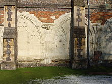
Pozostałości krużganków katedry w St Albans, hrabstwo Hertfordshire, Anglia.
Autor: Przemysław Sakrajda, Licencja: CC BY-SA 3.0
Katedra w St Albans, wnętrze.
Autor: Przemysław Sakrajda, Licencja: CC BY-SA 3.0
Cathedral and Abbey Church of St Alban, St Albans, Hertfordshire, UK


