Kenova
| ||
 | ||
| Państwo | ||
| Stan | ||
| Powierzchnia | 4,4 km² | |
| Populacja (2000) • liczba ludności • gęstość | 3485 1150 os./km² | |
| Nr kierunkowy | 304 | |
| Kod pocztowy | 25530 | |
| Strona internetowa | ||
| Portal | ||
Kenova – miasto w hrabstwie Wayne w stanie Wirginia Zachodnia w Stanach Zjednoczonych.
Miasto znajduje się w zachodniej części stanu, leży w przy granicy ze stanami Ohio i Kentucky, przy rzece Big Sandy.
W okolicach miasta 30 stycznia 2009 roku miała miejsce Katastrofa samolotu Seneca Piper PA-34 w której zginęło 6 Polaków.
Demografia
W 2000 mieszkało 3485 ludzi było 1594 gospodarstw domowych i 996 rodzin. Na 100 kobiet powyżej 18 roku życia przypada 83,7 mężczyzn. Średnia wieku miasta to 41 lat. Średni dochód gospodarstwa domowego w mieście wynosił $23 342 a na całą rodzinę $29,688. Średni dochód przypadający na mężczyznę $27 656 a na kobietę $22 500.
Ponad 99% mieszkańców stanowi ludność rasy białej.
Grupy wiekowe:
- 0 - 18 lat: 20%
- 18 – 24 lat: 9%
- 25 – 44 lat: 26%
- od 45 wzwyż: 45%
Związani z Kenova
- Robert Joe Long - amerykański seryjny morderca i gwałciciel, który zamordował 10 kobiet.
- Michael W. Smith - amerykański wokalista, autor piosenek, gitarzysta i keyboardzista.
Media użyte na tej stronie
Autor: Uwe Dedering, Licencja: CC BY-SA 3.0
Location map of the USA (without Hawaii and Alaska).
EquiDistantConicProjection:
Central parallel:
* N: 37.0° N
Central meridian:
* E: 96.0° W
Standard parallels:
* 1: 32.0° N
* 2: 42.0° N
Made with Natural Earth. Free vector and raster map data @ naturalearthdata.com.
Formulas for x and y:
x = 50.0 + 124.03149777329222 * ((1.9694462586094064-({{{2}}}* pi / 180))
      * sin(0.6010514667026994 * ({{{3}}} + 96) * pi / 180))
y = 50.0 + 1.6155950752393982 * 124.03149777329222 * 0.02613325650382181
      - 1.6155950752393982  * 124.03149777329222 *
     (1.3236744353715044  - (1.9694462586094064-({{{2}}}* pi / 180))
      * cos(0.6010514667026994 * ({{{3}}} + 96) * pi / 180))
The flag of Navassa Island is simply the United States flag. It does not have a "local" flag or "unofficial" flag; it is an uninhabited island. The version with a profile view was based on Flags of the World and as a fictional design has no status warranting a place on any Wiki. It was made up by a random person with no connection to the island, it has never flown on the island, and it has never received any sort of recognition or validation by any authority. The person quoted on that page has no authority to bestow a flag, "unofficial" or otherwise, on the island.
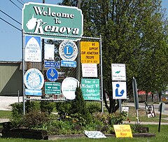
Photo of the welcome sign in Kenova, West Virginia located just east of the border with Kentucky.
Autor: Alexrk2, Licencja: CC BY 3.0
Location map of West Virginia, USA
Equirectangular projection, N/S stretching 130.0 %. Geographic limits of the map:
- N: 40.8° N
- S: 37.0° N
- W: 82.8° W
- E: 77.5° W


